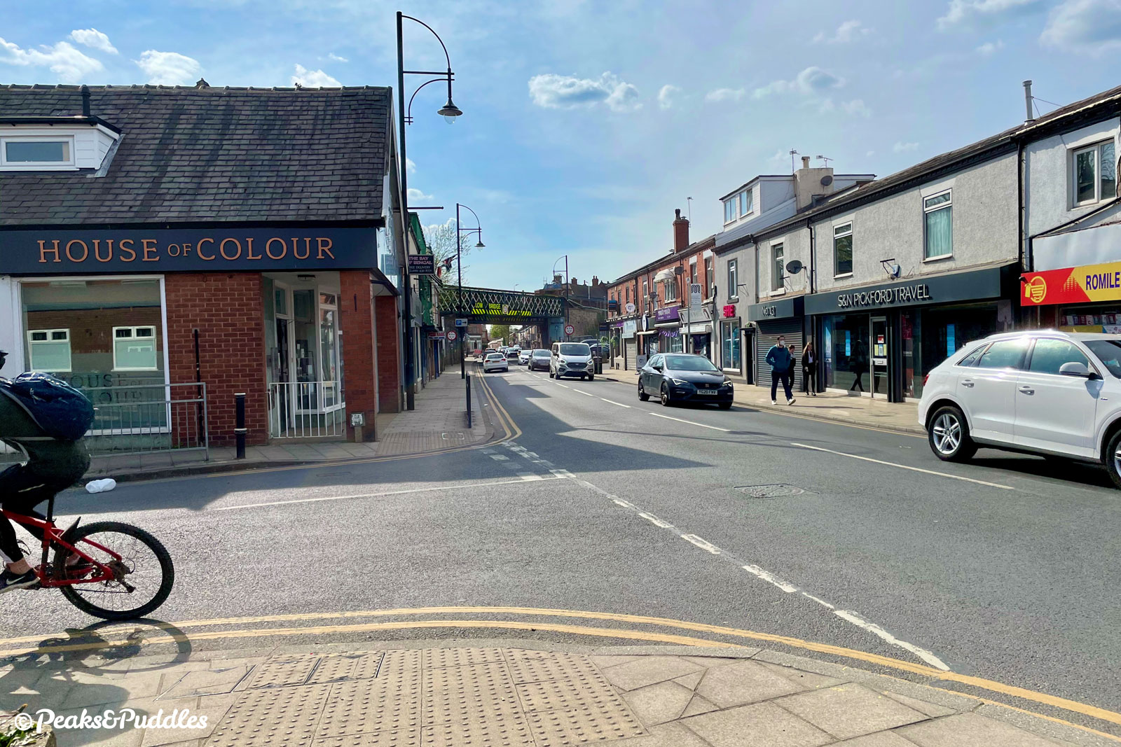
A whole range of proposals forming a new Bee Network active travel route between Romiley and Stockport are included in a consultation that ends in just a few days, potentially benefitting a big area of south east Greater Manchester around the River Goyt.
Though titled as the Romiley to Stockport Walking & Cycling Route the proposed improvements, coming from Stockport Council thanks to much hard work by WalkRide Romiley, also stand to benefit people travelling from Marple, Bredbury, Offerton and perhaps even further afield.
The consultation ends this Friday, 30th July 2021 Sunday 8th August 2021 (extended), so I cannot stress enough: if you want these changes to happen, tick the boxes and show your support. We have seen, from other consultations, entire proposals dropped completely when faced with lack of support or even opposition (and you just know someone won’t be happy).
Of course, if you think things could be even better, then definitely add those notes too. It’s not a perfect route, there are squiffy bits. Some of it is hidden a bit too far away from roads for a year-round commuter route and it only connects into the ropey shared pavements of the town centre itself. But it will vastly upgrade what is there already with so many much-needed easy wins.
The plans shown below are just excerpts from those presented in full on the council website. I’ve added my own photos, and some from Google Maps, to aid with visualising each location as it is currently.
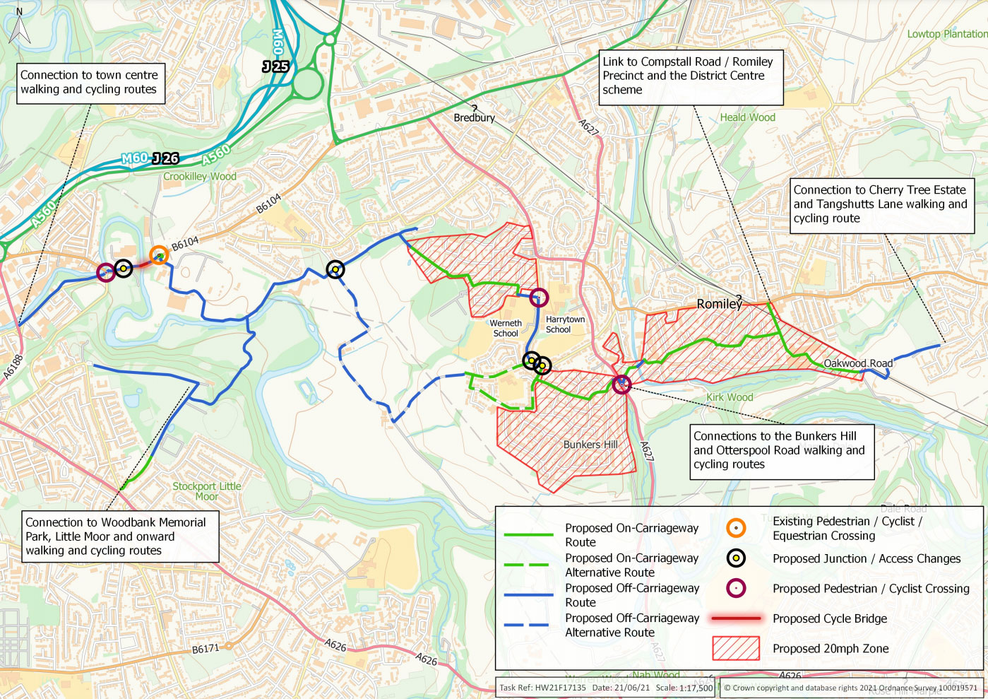
1. 20mph zones for more residential areas
Enough said. Three big blocks of south Romiley, Bredbury Green and part of Bredbury would become 20mph zones. Stockport just voted to adopt a 20mph limit on all residential streets, but while we wait for that to happen (and for the government to one day follow nationally), it’s a welcome move.
2. Cherry Tree footpath upgraded to bridleway
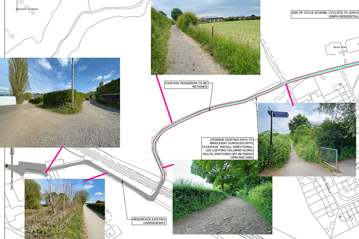
Now starting at the Romiley end of the route, a path already well-used by bikes but actually only a footpath (and very narrow in summer) could be officially upgraded to a bridleway, surfaced with Flexipave and given LED lighting (switched off from 10pm to 5am).
Part of me would be sorry to see the gentle old bumps gone on this route over the railway, between the Board Mill and Cherry Tree estate (also near the Peak Forest Canal), but having a route that everyone can use (and legally by bike!) is far more important. It seems the awful loose stone surface near Hyde Bank Farm will be properly surfaced too, which is no bad thing.
The route through the Board Mill would remain poor and unwelcoming, given only “shared space” signs and cycle markings, but then there’s probably not much else can be done.
3. One-way Green Lane canal bridge closed to motor traffic, becomes two-way cycle link
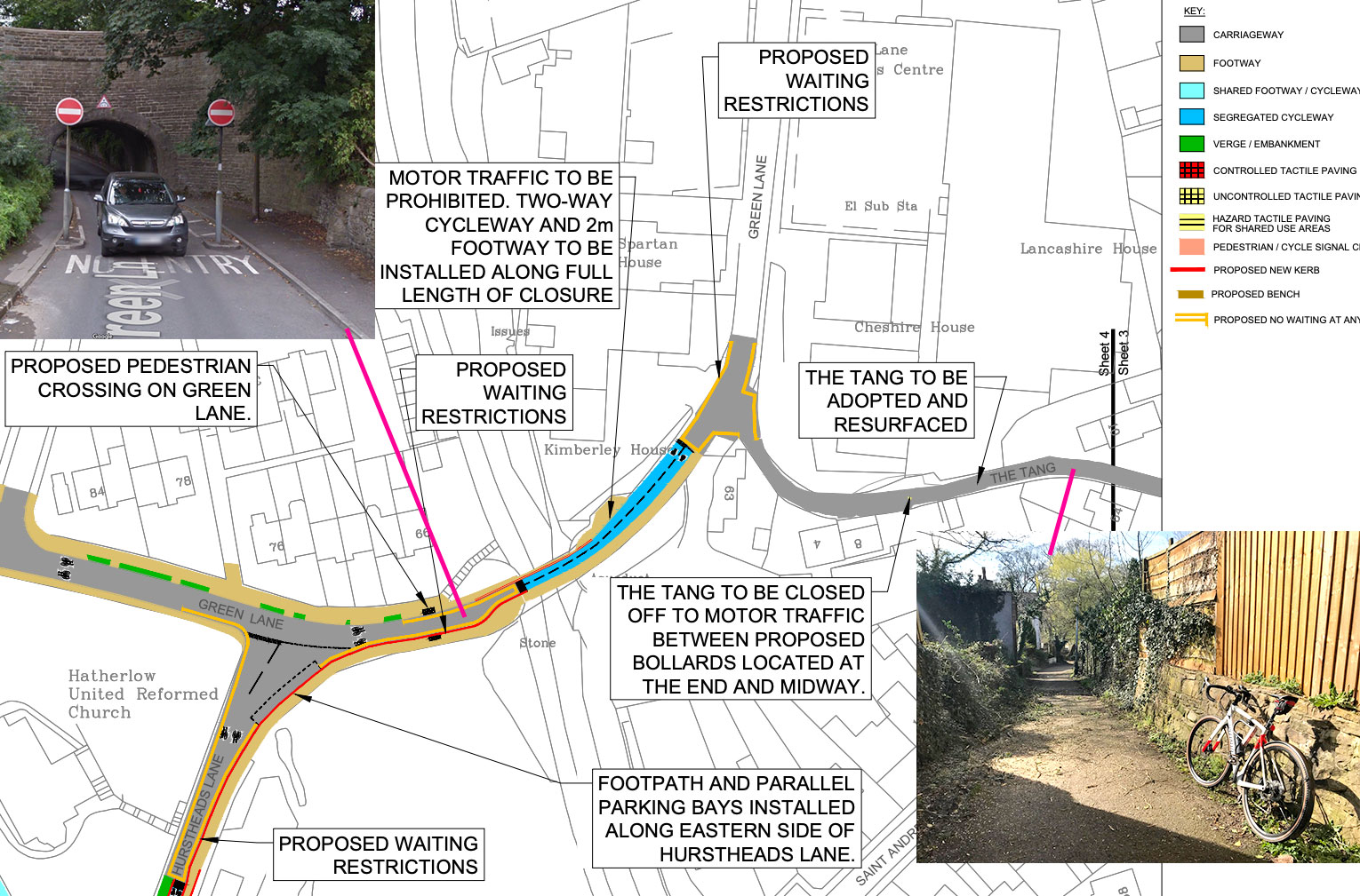
For Romiley this would absolutely be the biggest win; in fact, the entire route rests on it. Green Lane is currently basically a one-way, fast, rat run slip road out of the town, meaning that to cycle in your only alternatives are the seriously steep Vale Road or the horrible B6104 Stockport Road.
Closing the road under this canal bridge and making it a two-way cycle route (with a lovely new wide pavement for pedestrians too) solves so much. Especially car-free shopping trips to Aldi.
4. Toucan crossing for Hatherlow (A627)
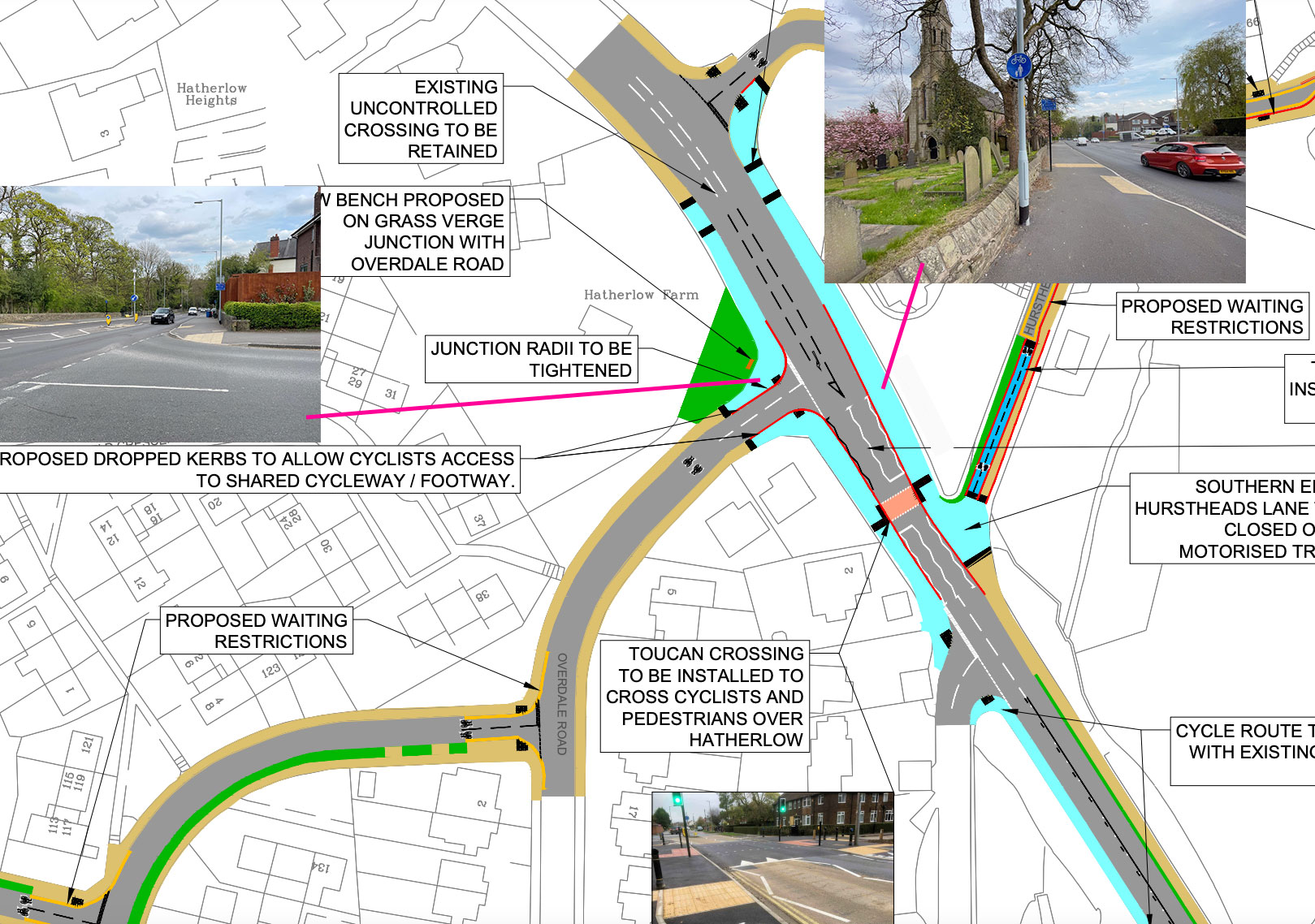
The next obstacle is Hatherlow and the busy A627 towards Marple and Hazel Grove, which Stockport Council installed a cycle track alongside a few years ago. As it stands it only has some pretty poor dropped kerbs to cross, which you can be stood at for an age waiting for a gap in traffic. Now a proper toucan is finally proposed.
Even better, one of the two roads up to Hatherlow behind the church — Hurstheads Lane — is proposed to be closed entirely, making the crossing so much easier to access. It’s an unnecessary route for cars with another just metres away, so this is a good call.
5. Segregated cycleway for Bredbury Green and Harrytown
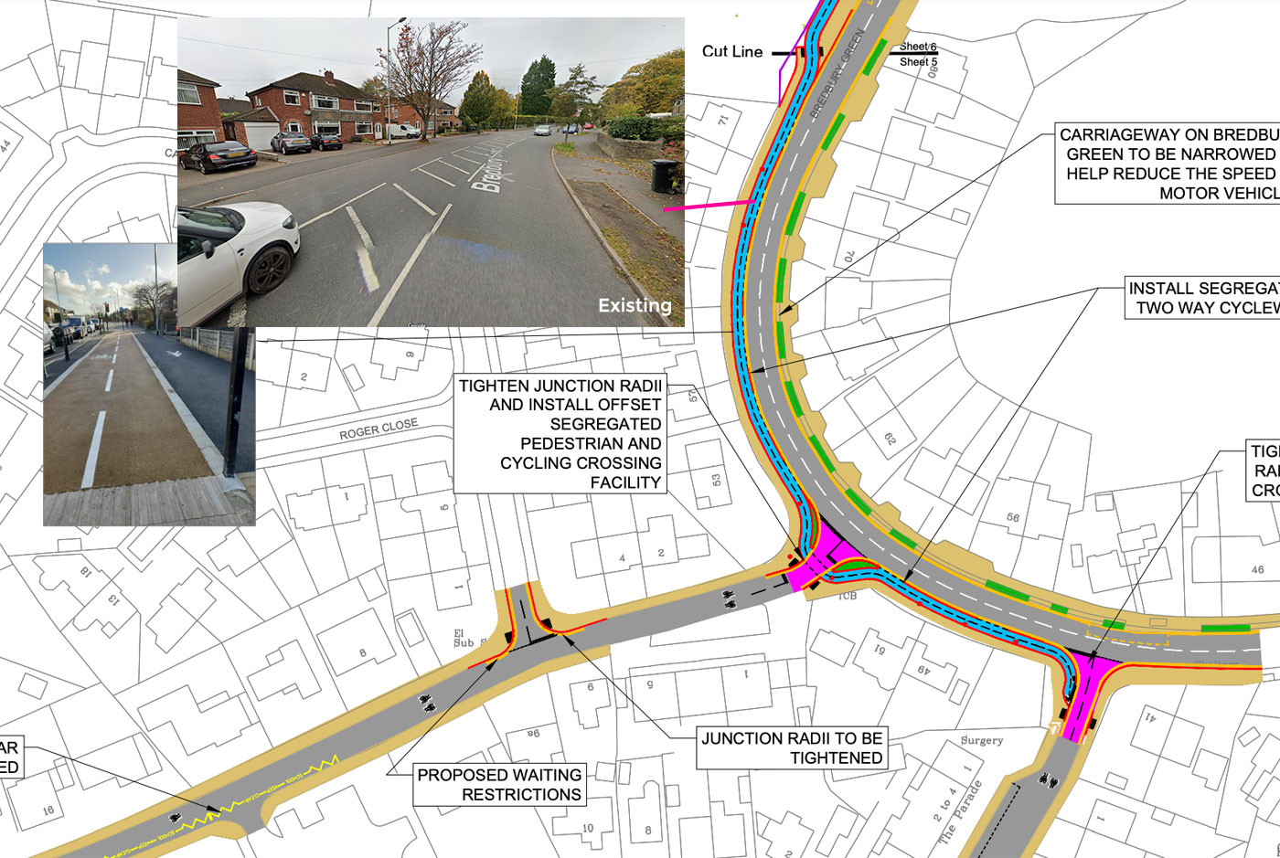
Apparently we can’t have safe, segregated cycleways on the borough’s motorway-like A6, but we can have them on random suburban backwater roads, huh.
While the route threads through 20mph zones around Bredbury Green, it needs to connect along the sometimes busy road for a short distance. Luckily, it’s wide enough for a separate two-way cycleway, which has parking restrictions and takes priority at side roads.
This would have the added benefit of connecting straight into Werneth and Harrytown high schools, with a new traffic light crossing which has been needed for decades.
Note that the cycleway is shown as a clearly-marked, buff-coloured track. It’s to be hoped that’s actually what would appear on the ground, not the ugly and unhelpful plain black tarmac currently being used in other schemes.
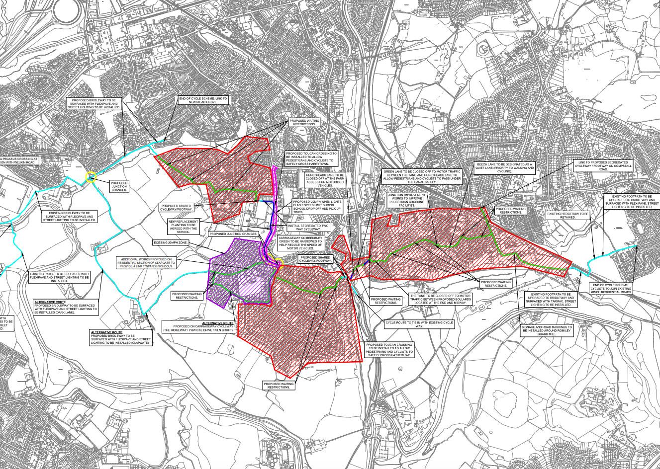
6. Flexipave for potholed parts of the Alan Newton Way?
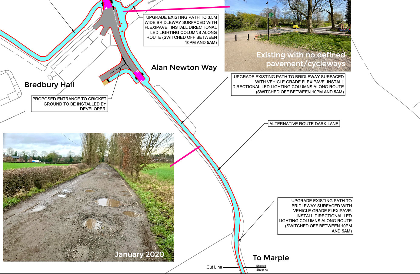
Alan Newton Way users, rejoice. Stockport Council is finally proposing to upgrade parts of this potholed off-road route to a Flexipave surface, made of recycled rubber and perfect for mud-free cycling and horse riding. Exactly how much of the route might be upgraded seems undecided.
The plans also show an “alternative” route that connects down Clapgate to Goyt Hall Farm, meaning the entire shoddy stretch through the farmyard would be properly surfaced. But when asked if this was an either/or situation or if both options could actually go ahead, given enough support, the council’s active travel team didn’t seem to want to commit.
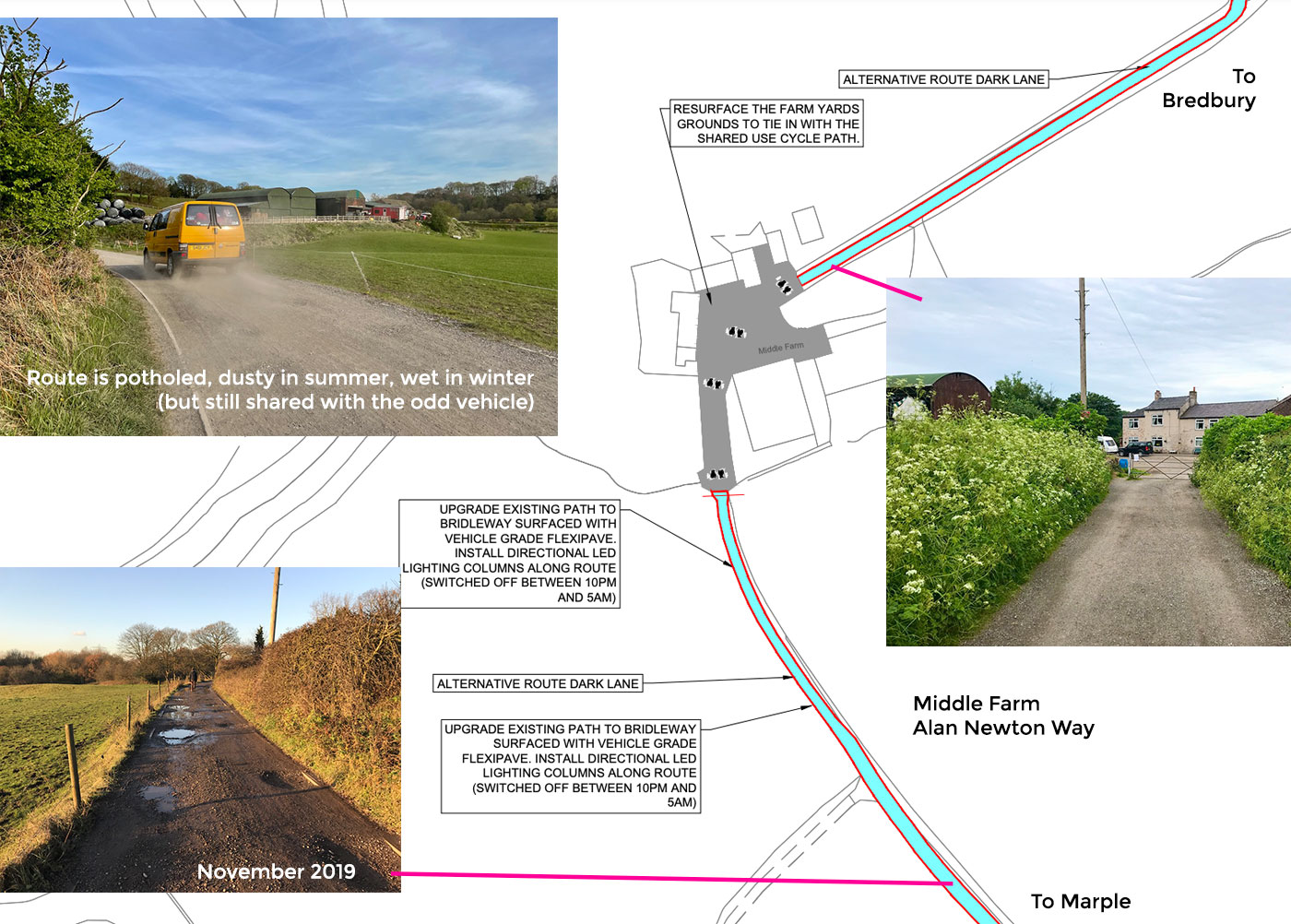
This part of the route was in fact only resurfaced a few years ago, but in a compacted stone that immediately formed large potholes. So if you cycle the Alan Newton Way, definitely support both options and add a comment that both should happen.
While Flexipave around Strines on the other side of Marple shows its brown-ish colour does a good job of fitting in on these kind of rural paths, a more controversial point might be the proposed lighting.
Though it’d be switched off between 10pm and 5am, a bit more detail on how the lighting columns themselves would look might be welcome. If they’re lower level or can be integrated onto existing telegraph poles, great.
7. New Pear Mill Link given the solid surface and lighting it should’ve had all along
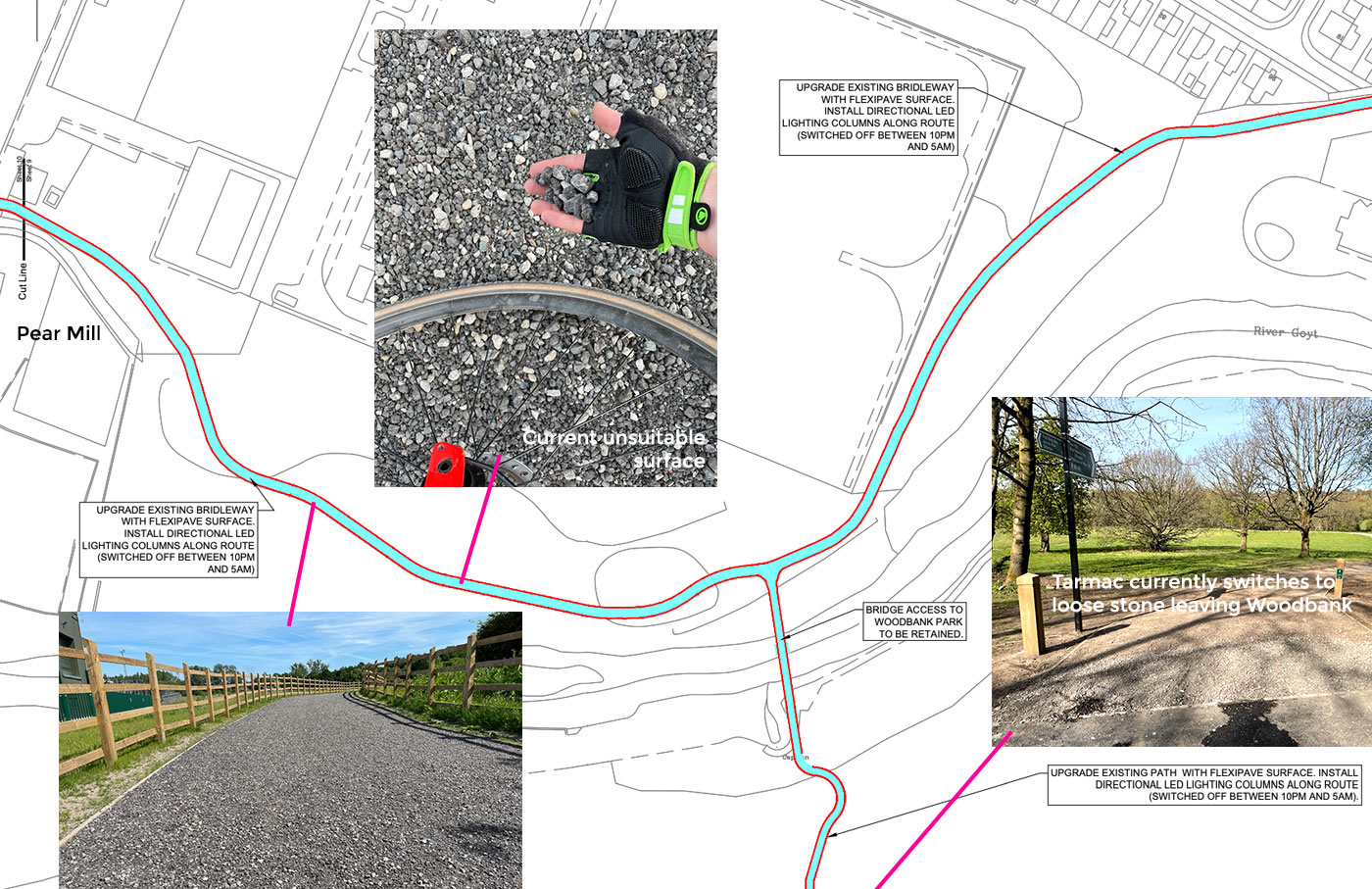
What’s that, you mean the brand new Pear Mill and Woodbank Park links don’t have a good surface for cycling after all? Yes, here we go — the brand new linking paths only completed earlier this year are now proposed to be resurfaced (or should that just be surfaced, full stop) in Flexipave. With lighting, too, which is a requirement for routes to be considered part of the Bee Network.
This will solve the current problem where part of the path is covered in truly awful coarse, loose stone. The council had stated they would return to fix it, but since nothing has happened in some months now I’m going to bet it never happens — it’ll be left as coarse, loose stone until it’s closed to do the job properly with Flexipave.
Another bonus is that the sketchy loose path into Woodbank Park will be Flexipaved too, and access controls at the park’s exits will be adjusted to lovely bollards. Currently these are full-width barriers with only a narrow gap and annoyingly with no dropped kerb. Links between Bredbury and Offerton will be much improved and actually, more direct across the valley than driving.
8. A brand new cycle-only bridge over the River Goyt to avoid Stockport Road West (B6104)
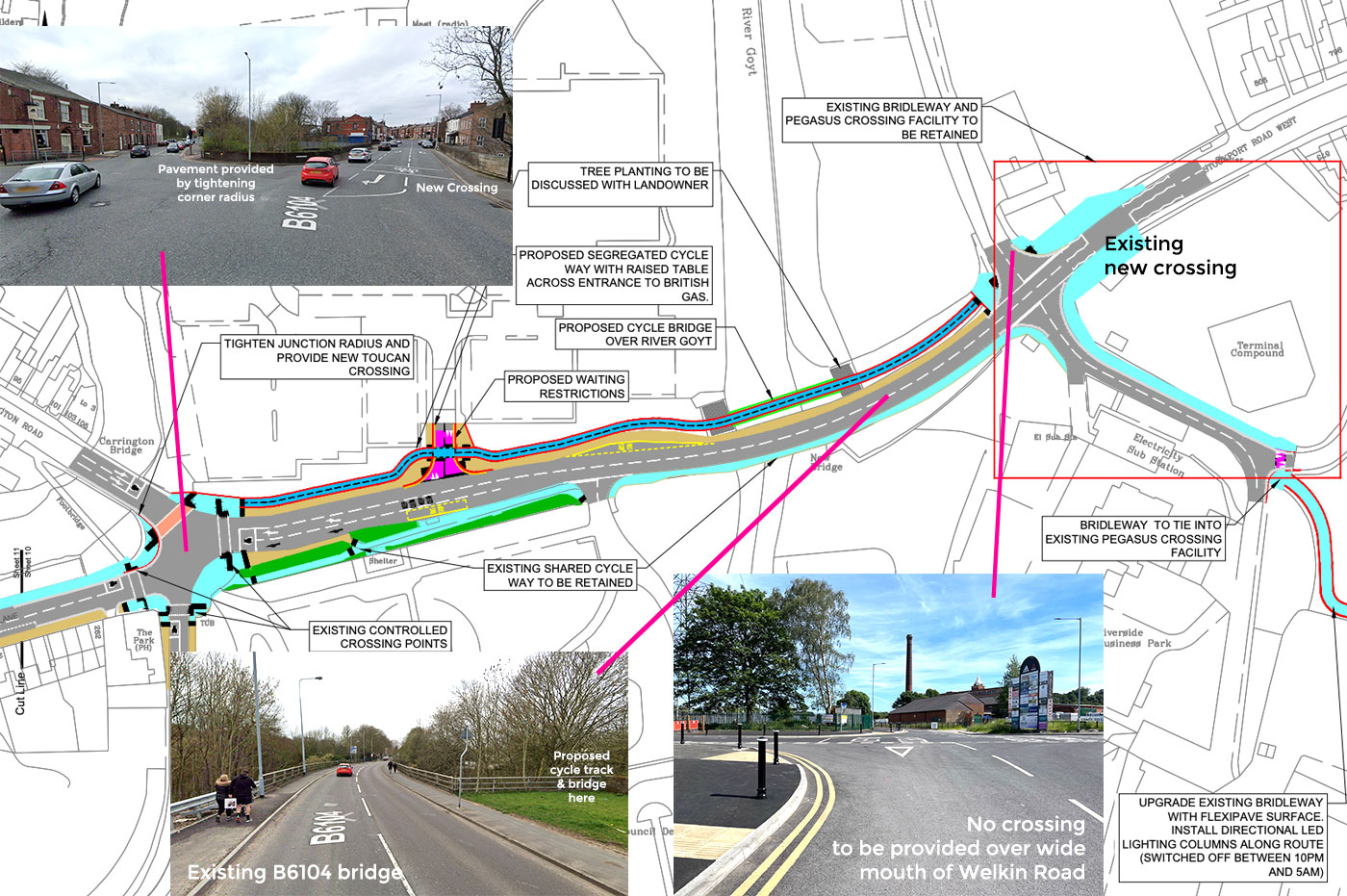
This one’s a real surprise. I was only thinking recently how frustrating it is that the road bridge from the end of the Pear Mill Link towards Stockport town centre isn’t wide enough for anything other than shared pavements squeezed down its sides. Now, they’re proposing a brand new bridge next to it!
This would be a cycle-only bridge (the first in Stockport?) to the north of this busy road, meaning the pavements stay on the current bridge and cyclists would be advised to use the new Pegasus crossing to the east of the Pear Mill junction in order to access it.
A major negative is then having to cross the wide mouth of Welkin Road to get to the cycle track. That’s really poor, especially considering this area seems primed for development and much more traffic using that road, and it would be worth noting this in the comments box.
On a separate point, where I looked at the challenges of a cycle route alongside the A6 at High Lane, it became clear the cutting of Middlewood Way was a major obstacle itself. Feeling a bit audacious, I suggested a new cycle-only bridge beside the narrow A6 bridge, to continue a route straight over. Turns out, it’s not such a bold idea…
9. New Bridge Lane shared pavement upgraded with (some) user separation
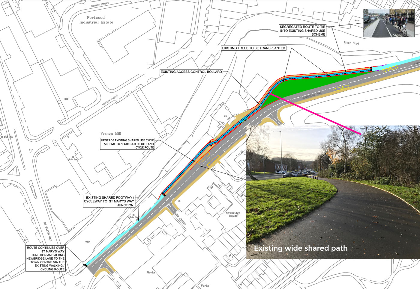
When Stockport began its multi-million pound Town Centre Access Plan or TCAP for short, the borough’s highways planners made the frustratingly short-sighted decision to go with shared pavements for almost all the new cycle “infrastructure” added — even where there would’ve been space for a proper, separate cycle track.
New Bridge Lane was exactly one example. A far wider road than it needs to be, it was given only awkward shared pavements with clumsy, narrow crossings and no priority over side roads. Now, already, they’re (or rather, we’re) paying for this short-sightedness by undoing some of that work.
A short stretch of the path, where it’s wide enough, will be split into separate pedestrian and cycle sides. Somewhat pointless, though, when everyone’s squashed together again a few metres later. It’s a requirement of the Bee Network guidelines that users should be separated as much as possible. They could definitely do better here, but maybe that’s something for another project.
A more positive intervention is a new crossing north of the Carsington Road/New Zealand Road junction, near Vernon Park, allowing the potential cycle track to cross straight over in one movement. The current crossing beside the pub on the south side there is really awkward for shared use.
Unfortunately, the TCAP is going to haunt Stockport for years or even decades to come, as every Bee Network-quality route into the town centre is forced to feed into its confusion of shared pavements. It would be good to eventually see a Bee Network proposal for the centre itself, giving a core east-west/north-south route spine that actually meets Greater Manchester’s new criteria and can be fed into by these radial routes.
10. It’s not just about Romiley, or cycling
Connecting a route in from south east Stockport, these proposals would spread benefits far and wide. In fact, you could never visit Romiley and still find an improvement to your cycling options.
Marple, Offerton and Bredbury can all benefit and with the upgrades proposed for the popular Alan Newton Way it begins to form a good (if leisurely) spine between them. Link in other routes, and journeys even from across the Greater Manchester border start to look more doable, even if provision for cycling beyond is going to increasingly look like a cliff-edge.
We do still need more cycle infrastructure alongside our actual roads — yes, that’s very difficult in places with our old, narrow roads, but there’s perhaps still too much an element of shunting cycling into the shadows with parts of this plan.
Yet at least proving a reliable surface and lighting along these off-road sections makes them far, far more appealing. The 20mph zones, crossings, widened pavements and more also give a much improved pedestrian experience.
Upgrading at least two footpaths to brand new bridleways benefits equestrians (and others) massively. Stockport have been consistently proactive on this one and must be applauded for it — Cheshire East, Derbyshire, take note.
The most important thing now is to actually support the good bits of these proposals. Fill in the survey, tick the boxes, make it happen. Then let’s move on to even bigger and better, please!