B5470 closure: note that the ‘Brickworks climb’ segment of this ride has been impacted negatively by traffic displaced by the closure of the nearby B5470, now mostly using this narrower road instead. During the closure I’d recommend you avoid the Brickworks entirely and for this route try climbing Blaze Hill out of Bollington instead, then either turn left onto the B5470 (here largely traffic-free for once, with a pedestrian bypass around the landslip) or continue strenuously up on the classic route past Jenkin Chapel to Pym Chair. View this suggested option mapped here (but note it is only a suggestion and subject to the B5470 being passable by cycle during the works.)
Epic upon epic upon epic, a trio of strenuous but spectacular, classic hill climbs lead from the Cheshire mill town of Macclesfield up to the isolated Cat & Fiddle Inn, via the Brickworks, Windgather and Derbyshire’s Goyt Valley.
Route details
- Distance
 26.8 miles / 43.1 km
 - Elevation Gain
 1067 m / 3501 ft
 - Time allow 3 hours 30 minutes
- Difficulty
 Very Challenging
 - Terrain 10% Off-Road Path Traffic-free trails, towpaths & cycleways 90% Road Quieter lanes, sometimes brief busier roads 0% Unpaved Bumpier tracks & bridleways
- Suited to
 All Bikes
  Gravel Bikes
- Suggested Start Macclesfield SK11 6JP SJ 9188 7363
- Places Bollington, Cat and Fiddle, Cheshire, Cheshire East, Derbyshire, Derbyshire Bridge, Errwood, Goyt Valley, High Peak, Hurdsfield, Kerridge, Kettleshulme, Langley, Lyme Handley, Macclesfield, Macclesfield Forest, Pott Shrigley, Pym Chair, Sutton, Windgather Rocks
- Attributes Accessible by train, Bridges, Car parking, Circular loop, Dales, Ideal for electric bikes, Industrial heritage, Moors, National Cycle Network, Pubs and cafés, Railways, Reservoirs, Rivers, Rural heritage, Steep climbs, Towns and villages, Urban, Views of hills and peaks, Views of open countryside, Views of towns and cities, Woodlands and forests
England’s second-highest public house, atop wild and windswept moorland on the western edge of the Peak District, belongs to Cheshire, a county renowned for it’s flatness. That kind of twist sets a good tone for this ride: a largely classic loop ticking off multiple must-do hill climbs — but with some unexpected quirks.
One hill climb definitely not included is the A537 from Macclesfield to the Cat and Fiddle itself. Though featured in Tour of Britain routes, it’s notorious for its sharp bends and frequent accidents, offering little joy unless you’ve your own police escort and team car. Instead the route leaves Macclesfield, famous for its silk, via the former railway line to Bollington, where the River Dean created a far more hilly industrial hub.
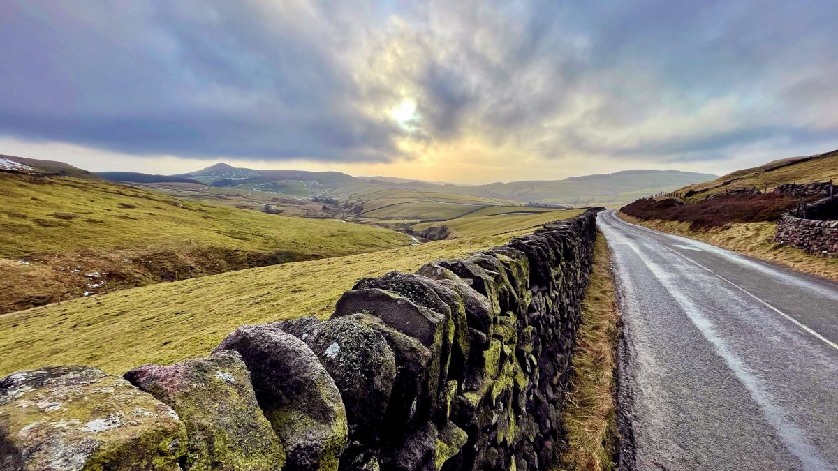
Traversing this steep valley, the first quirk is encountered wheezing up Beeston Brow, a comedy Hovis Bread climb of cobbles and absurdly pitched stone cottages. The rewarding panoramic views over the Cheshire plain offer a final glimpse of what flat looks like, before turning to Pott Shrigley and the beloved “Brickworks” climb. Beyond the clay and coal seams of Bakestonedale Moor, a vista into the High Peak beckons, but not before another twist.
Unpleasantly fast and increasingly busy, the B5470 over Todd Brook to Kettleshulme is avoided by a lengthy but worthwhile diversion onto a rather quieter road to the north with far better views and a wild single track lane. Looping stealthily into a village sited 1,000 ft (300 m) above sea level, this tight, steeply undulating and often gravelly tarmac is completely at odds with the archetypical Cheshire lane.
Passing a theatrical outcrop of gritstone rocks, the Windgather climb is likewise a memorable reminder that the hills of the Peak belong not only to Derbyshire. The county border is only finally crossed atop Pym Chair, once a packhorse route used for the trade of Cheshire salt. A long, sweeping and spectacular descent begins the dip into Derbyshire, dropping from heather moorland, radiating a purple sweet scent in late summer, to the relatively modern plantations and reservoirs of the manhandled but still evocative Upper Goyt Valley.
After a rollicking ride alongside Errwood Reservoir, completed in 1967 to sustain Stockport and surrounding areas, the valley narrows and the one-way climb tracing the River Goyt to its source heralds a feeling of true wilderness. Out of the trees and beyond Goytsclough Quarry, between soggy peat uplands, this magical, isolated pass is surely some of the most awesome cycling in England, let alone the Peak District. It’s hard to understand why cars are still allowed (necessitating the one-way system and preventing a downhill ride).
If reaching the old county border of Derbyshire Bridge feels a surprisingly easy climax, that’s because it’s not: the road now makes a final, far more taxing hurrah right up to the Cat & Fiddle Inn itself. As the 1826 public house appears high on the horizon, the magnificent valley drops away below to become an insignificant dent in this barren plateau.
Following a quick jaunt on the main road, over the summit and back into Cheshire, the return run diverts down to peaceful Wildboarclough. Rising up to a truly special hidden chapel, it then drops thrillingly through Macclesfield Forest and back into the town, via a couple more quirky but quiet cobbled streets.
Route map
Where to start
Macclesfield town centre, on Waters Green right beside the railway station, is the lowest part of the route and provides an easy preamble along the smooth, off-road Middlewood Way before the climbing begins.
If you’re heading onto the route from elsewhere, Middlewood Way also provides a direct, off-road feeder from Marple and the edge of Greater Manchester. See the Beginners’ Brickworks cycle route for an alternative way to reach the first climb.
From the High Peak, the ride can also be approached using a quieter route out of Whaley Bridge (as seen in the Goyt Valley Grinder cycle route), then the concessionary trail to the east/left side of Fernilee Reservoir. This alternate ‘Goyt Start’ is included under ‘Other route options’.
By train: Macclesfield railway station is right where the ride begins and the only one along the route, on the line from Stoke-on-Trent to Manchester. Middlewood railway station on the Buxton line (right beside Middlewood Way) is the next best link, or Whaley Bridge railway station if starting from the High Peak.
By car: There are plenty of signposted, pay car parks in and around Macclesfield town centre.
Things to note
- Middlewood Way has a good tarmac surface for this length. The snakes-and-ladders arrangement of ramps either side of the Silk Road bridge provide a quirky cycling proficiency check. However, these and the ramp onto Clarke Lane could be difficult or even impassable for non-standard cycles.
- After the Brickworks climb, the route heads north largely just to avoid the very unpleasantly fast and increasingly busy B5470 road climb into Kettleshulme. These additional ups and downs on the quiet single track lane through Todd Brook are a worthwhile diversion (they also feature in Hidden Hills in High Peak), but require their own care due to narrowness, steepness and blind bends. The same applies to the descent from Forest Chapel later in the ride.
- The one-way road up through the Upper Goyt Valley to Derbyshire Bridge is closed to motor traffic on summer Sundays from 11am to 4pm, making this a good time to ride it, though note that cars can still be encountered during that time, if they’ve parked up earlier. There’s a petition ongoing to close the upper section of the road to motor vehicles entirely.
- Atop the Cat and Fiddle, the A537 is only a very brief part of the route and sometimes in fact surprisingly quiet, but still needs care. With a superb view right back across the moorland before joining, it’s worth waiting for a long gap in traffic to enjoy it in peace. After a stop to admire the view beside the Cat & Fiddle Inn, it’s all downhill to the left turn. Take it all easy and avoid leaning in too keenly on the two sharp right bends which can have loose gravel and sudden wind gusts.
- Important: The Cat and Fiddle summit can be very windy and/or shrouded in fog in poor weather, or completely snowed over in winter, even if the weather down below seems fine. Always check the local forecast, wait for a nice calm day and take this landscape and the weather seriously. There’s a useful webcam here.
Route stage-by-stage
- Head north on Gas Road, continuing straight ahead through the bollards under the railway and road bridges, along a rather narrow riverside path. Where it forks at a brick wall, turn left and follow the shared pavement around to the busy Hursfield Road. Use the toucan crossing and turn right, following the shared pavement around the corner alongside Black Lane.
- Cross the supermarket exit road to join the Middlewood Way. Follow the trail for 2.7 km (1.7 miles), over a road crossing and a large wooden bridge over the Silk Road bypass. Between 1869 and 1970 this was the Macclesfield, Bollington and Marple Railway, cutting a route across the far east of Cheshire and even briefly connecting the town by rail to Buxton, though the lengthy journey time was never popular. At the first old railway overbridge, follow the ramp to the left to exit up to the road.
- Turn left on Clarke Lane, crossing the Macclesfield Canal and climbing gradually towards Kerridge with a final steep rise. Descend Jackson Lane then turn right into the very narrow Chancery Lane. As the lane descends again, turn left into High Street with views over Bollington. Continue around a bend then take the first left into Water Street, crossing the inconspicuous River Dean near the bottom. At the traffic lights turn a sharp right onto Palmerston Street.
- Immediately after a converted church, turn left across a large cobbled space into Beeston Brow, signposted “unsuitable for heavy goods vehicles”. This brilliant cobbled lane climbs the hillside like a ladder, with an impossibly sharp right turn onto uneven tarmac which proves perhaps even steeper. After just 250 metres, but some struggle, it relents and bears left to become Long Lane.
Suitably named, this sedate tree-lined stretch of tarmac is strung across the ridge side with some fabulous views over Cheshire – the relatively low sandstone hump of Alderley Edge being the only notable break in the flat. As the lane ends, turn right onto sometimes busier Shrigley Road, dropping towards the village of Pott Shrigley and into the Peak District National Park.
- Beside St Christopher’s Church, turn left into Bakestonedale Road and the start of the Brickworks climb, ascending. The challenge can be roughly split into thirds, the first being a relatively short climb to the Old Brickworks itself. Now a small industrial estate (with its own coffee roastery for passing cyclists), it began life in the mid 19th Century as two small brickworks either side of the road.
These brickworks tapped into the ideal seams of both clay and coal, which were mined under Bakestonedale Moor to the north, the next stage of the climb. Rounding the corner beside an isolated farmstead, a steep pull is required to heave up into the final stage, around Brink Farm, with a view to the right opening up of the ride ahead.
- At a t-junction with the fast and busier B5470 Macclesfield Road, turn left, taking care as visibility here over the brow of the hill is not the best. Plummeting immediately down the hill into Gnathole Brook, apply brakes well before the very sharp bend at the bottom, if not all the way down, to make it around in one piece.
Turn left at a junction sometimes hidden until the last minute by vegetation, into Higher Lane. The road climbs for one kilometre (0.6 miles) up around the side of Reed Hill; the gasping turns of each tyre placated by the brilliant view into the High Peak. A whooshing descent and a hidden dip give a surprise moment of g-force into the foot of Sweet Hill.
- As the road bears left, turn right into Cornfield Road. A roller coaster of a hidden lane dipping down and up above Todd Brook, which feeds the infamous reservoir, this falls into Holme Wood before climbing steeply to Cornfield Farm. A frighteningly sharp and narrow descent then drops into the brook itself, blind bends and the occasional farm vehicle adding to the peril, pulling out again around a gravelly bend.
Reaching the calm of a small t-junction at Coalhurst, turn right onto Kishfield Lane, completing the thrill ride around the brook. Where the lane forks at a small plant nursery, bear right into Paddock Lane, passing Kettleshulme Church and bearing left up a near suburban street in one of Cheshire’s hilliest and easternmost villages.
- Encountering the B5470 again, turn right and then just a short distance ahead, after the primary school, turn left into Side End Lane. Although it’s been almost entirely uphill since the bottom of Todd Brook, this is where the Windgather climb officially begins, ascending a hefty 207 metres (680 ft) over 3.2 km (2 miles).
The climb can be roughly split in two, with the impressive gritstone rock face beloved by climbers coming around half way and the first half considerably more strenuous. Higher up, the gradient eases but the lane narrows slightly. Stopping at the top is mandatory to take in the view: to the right, over the Cheshire plain with the white glint of Jodrell Bank’s Lovell Telescope, and behind, a 180-degree panorama over Cheshire and the High Peak.
- Turn left and soon after a cattle grid the true summit of Pym Chair is crossed, a protruding seat in the long valley-side ridge which runs south to Shining Tor, Cheshire’s highest point. An ancient trackway, believed to be a Roman road, and certainly vital in the trade of salt from Cheshire to Derbyshire, this road known only as The Street provides a thrilling entry to the Goyt Valley. Swinging first across moorland with grand views over the Dark Peak, an unrelenting descent requires a fierce pull of the brakes as Errwood Reservoir comes into view. The larger and later of the two reservoirs, completed as recently as 1967, this kilometre-long expanse of water to serve Stockport and the urban area downstream severed the historic crossing of Goyt’s Bridge into Derbyshire.
Following the road to the right and along its shores, another victim of the valley’s flooding is hidden off in woodland to the right. Errwood Hall is today only ruins, but from the 1840s to the 1930s stood as a splendid country house for the wealthy Grimshawe family in a magical setting. Having been turned into a youth hostel a few years prior, the hall was demolished during construction of the lower Fernilee Reservoir in 1934. The evocative ruins are a short push along a good path to the right, just after the incongruous modern road bridge.
- Beyond the Errwood Hall car park, the Upper Goyt Valley road becomes one-way, uphill only, for all traffic; a change initiated in 1980 to manage the increasing hoards of motorised visitors driving out from Manchester, yet also frustrating what was (and should still be) a two-way cycle route to and from the wider Peak. Nevertheless, the next 3.5 km (2.2 miles) climbing a mostly easy-going 135 metres (442 ft) into the isolated upper valley is one of the most magnificent places to cycle in the whole National Park. With the Goyt now a noisy, free-flowing stream below, it climbs between woodland and forest, feeling wild and romantic — but still heavily under man’s influence. Not just from the larch plantations, being progressively felled and replanted, nor the managed heather moorlands, a stunning purple in late summer.
At Goytsclough Quarry, where the lane opens out against the chiselled, dripping rock faces, an entire paint mill grinding powders stood with its own, surely bleak, millworkers’ cottages in the late 1800s. The earlier stone quarry owned by Thomas Pickford exported its slabs via trains of packhorses. Today the attraction here is the old packhorse bridge, saved from the flooded lower valley and rebuilt stone by stone.
Around the next, slightly steeper bend, the full drama of the upper valley unfolds, widening and deepening below Goyt’s Moss to become a true moorland pass, the road’s passage strung out far into the distance. Derbyshire Bridge, a small stone crossing of the Goyt, marked the historic border between Cheshire and Derbyshire until boundaries were realigned in the 20th Century.
- Crossing a cattle grid with toilets and a car park ahead, turn right for the final pull up out of the valley. Another bridge marks a quick return to historic Cheshire, though the modern county border is much higher up on this climb, which somehow often comes as a surprise no matter how familiar you are. As the. As the inn begins to loom on the horizon even a faint wisp of wind can make it a struggle, but the spectacular views to the right are a feast for the eye, the vastness and intricacy of the varied landscape almost impossible to take in. Finally approaching the A537 Macclesfield Road, the climb has totalled 236 metres (774 ft) over 5.3 km (3.3 miles) from Errwood.
Waiting for a good gap in traffic on this fast road, turn right towards the Cat & Fiddle Inn. Famous as England’s second highest public house (Yorkshire’s Tan Hill Inn boasts an extra eight metres), this roadside icon dating back to the 17th Century is now taking on a new life as the UK’s highest altitude whisky distillery. It’s worth stopping again to take in the view here, before a swift onward descent around a couple of hair-rising high bends.
- The left turn opposite Peak View Tea Rooms down into Clough Brook is a welcome sight, but the handlebar-gripping descent has only just begun. With views across Wildboarclough to the pinnacle of Shutlingsloe, looking like a mountain but very much a hill, the lane speeds downhill between stone walls and farmland into a nook named Bottom-of-the-Oven. At a phone box opposite the Stanley Arms turn left, then turn right signposted “Macc. Forest”. The sudden pull up rewards with a view over this hidden valley, explored in the Cheshire Mountains of Macclesfield cycle route.
- Turn right, signposted Forest Chapel, onto an even narrower lane, climbing arrow-straight up the hillside. Around a bend at the top, sighting Forest Chapel ahead, the reason for this diversion becomes clear. Sitting with just a handful of cottages, perfectly isolated in a fold in the landscape, St Stephen’s Church always feels a very special place. Dating back to the late 1600s, the Grade II-listed chapel was rebuilt in 1834 in sandstone with stone roof slate from nearby Kerridge. Services are still held throughout the year, including an annual rush-bearing in August where the whole chapel floor is covered in plaited rushes and harvest flowers adorn the pews. Otherwise, simply stopping to listen to the wind whistling across the moors is atmospheric enough.
From Forest Chapel, double back to begin descending alongside Toot Hill into Macclesfield Forest (a left turn from the lane in). Though definitely the quieter of the two very steep and narrow roads up through the forest, take care with the sharpness of the descents and sudden bends. Alongside the thrilling ride are views across the dramatically undulating carpet of trees, being progressively restocked but originally part of the Royal Forest of Macclesfield which covered much of this side of the Peak. Toot Hill above the start of the descent has visible earthworks from a medieval deer enclosure.
- At the Leather’s Smithy pub, the earth dam of Ridgegate Reservoir, built in the late 1800s, extends opposite. Continue descending straight ahead/right on Clarke Lane, passing Bottoms Reservoir with the dark, quarried promontory of Tegg’s Nose above. In Langley, bear right at the Methodist church from Main Road onto Langley Road. At the Church House pub, bear left into Church Lane, passing the 1840 church of St James, built after the booming silk industry pushed wealthier folk out of Macclesfield. A dip over Rossendale Brook leads to Sutton Lane Ends.
Turn left then right into Walker Lane, beside the traditional village sign which celebrates local wildlife artist Charles Tunnicliffe. Leave Sutton then turn right at a crossroads into Bullocks Lane, descending towards the Macclesfield Canal with a fabulous view back to the hills which would’ve been missed by heading straight downhill. (The towpath here offers a way to avoid the busier centre of Macclesfield, though it is especially narrow in places and involves walking over a trademark roving bridge with slippy cobbled ramps.)
- At the next t-junction, turn left onto slightly busier Byrons Lane for a quick arrival into Macclesfield around a few bends lined by houses, continuing all the way to the traffic lights. Here, turn left then immediately left again to double back under the same bridge on Old Mill Lane.
- Continue ahead to almost meet the main road, but instead turn right into Pool Street then right onto Windmill Street, beginning a final twist onto some characterful hidden streets. Immediately after the mainline railway bridge, turn left into Knight Street, following up a narrow hill to a first length of cobbles. Turn left onto Bank Street, follow around the bend onto Turnock Street, crossing over a couple of roads, one busier. Thornycroft Street presents another length of bumpy cobbles, before a sharp turn onto Glegg Street passing St Paul’s Church.
Turn right onto Green Street then second left into the grand finale: the wackily-titled Cuckstoolpit Hill. Where the route began climbing Beeston Brow, now comes the cobbled descent — with a cracking view over this simultaneously gritty and grand town. There is also a smooth pavement alongside for those who’d rather opt out. At the bottom, join the traffic lights to continue straight over the big junction, under the railway line back into Waters Green.
Other route options
- Trentabank Tumble
27 miles (43.5 km), 3377 ft (1029 m)
An alternate route downhill at Macclesfield Forest, passing Trentabank Reservoir instead of Forest Chapel.
In stage 13, instead of R turn to Forest Chapel, continue SA. At t-junction, TR for steep 16% descent, passing reservoir and ranger centre, then sharp R then L to continue alongside Ridgegate Reservoir. Rejoin main route at stage 14, TL in front of pub. - Goyt Start
15.4 miles (24.8 km), 1530 ft (466 m)
Start from Whaley Bridge to begin with Goyt Valley. Windgather climb can be skipped to return to High Peak via Todd Brook and extra, difficult but short cobbled climb.
Head south on main Buxton Road. TL into Old Rd, follow to t-junction. TL onto B5470. TR into Elnor Ln, climbing steeply, then becoming Taxal View. At t-junction, TL onto A5004. (! Busier, fast road) TR into lane forking R, downhill. After sharp bend, TL then continue SA past parking area onto trail alongside reservoir, ending with steep incline alongside dam. TR to cross Errwood dam, climb then TL to join route at stage 10.
To complete the ride and return to Whaley Bridge, the above route can be followed in reverse; alternatively:
At stage 7 instead TL into Kishfield Rd, becoming Start Ln, leading to steep, tricky cobbled climb. Follow lane downhill to t-junction. TR onto Whaley Ln.
These options are mapped out in the Pocket Guide and alternative navigation files are included in the GPX collection and single route download.
A Peaks & Puddles + Route
This route guide is available exclusively to supporters and is hidden from the main website. Please don't share the link anywhere publicly.
Original photography, words and design by Anthony Sheridan unless indicated otherwise. Found this guide helpful? Buy me a coffee to help keep the wheels turning!
The all-important disclaimer: While great care and attention has been put into gathering these routes, ensuring details are accurate and determining their suitability, all information should be used as a guide only and is not a replacement for using your own judgement or research when setting out on new adventures. Peaks & Puddles/the author cannot be held responsible for any issues that may arise from the riders own decision to ride a section of indicated route.
Always ensure your equipment is safe and legal for use and that you are well prepared, carrying everything necessary including access to a good map. Follow the Highway Code and the Countryside Code at all times. Respect the landscape, the wildlife and the people you encounter. And after all that, have fun!