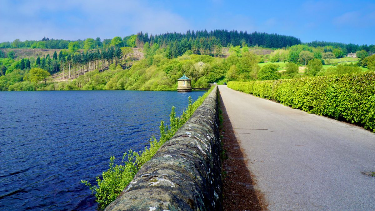
Goyt Valley Grinder

Escaping to the spectacular Goyt Valley reservoirs via canal and quieter roads, a superb gravel fire track through the forest leads to the challenging Pym Chair climb, a thrilling descent past Windgather Rocks and the enchanting hamlet of Taxal.

Route details

  • Distance 17.6 miles / 28.3 km
  • Elevation Gain 588 m / 1930 ft
  • Time allow 2 hours
  • Difficulty Challenging
  • Suited to Gravel Bike Hybrid Bike Mountain Bike
  • Notes Some moderate gravel tracks and broken tarmac, one short bumpier farm track. Road Bikes: can follow alternative route skipping these sections.

The reservoirs of the Upper Goyt Valley flooded this landscape not only with water but with people, too. Once a remote, rural corner of Derbyshire, the completion of the Errwood Reservoir in 1967 saw the valley become a prime day trip for new motor car owners, a testing popularity it still struggles with today.

It was much earlier that Fernilee Reservoir began the transformation. Completed in 1938 by Stockport Corporation Waterworks to supply the growing towns below with water, the building of the dam was a major feat requiring a temporary “tin town” for workers and its own railway.

The gravel fire track through the Goyt Forest.

Yet despite the green surroundings, the upper valley had long been industrialised to some degree. The new reservoir left intact the trackbed of the Cromford & High Peak Railway, a dizzying freight line linking two canals across the Peak, on which trucks were hauled up huge inclines. While the line had opened in 1831, by 1892 the section through the Goyt Valley had been mothballed.

Even down on the valley floor, the River Goyt’s course was surrounded by Chilworth Gunpowder Factory, a large and dangerous mill that had its own tramway and spewed out pollution. The entire complex was largely demolished in the 1930s and now sits submerged deep below the reservoir’s waters.

While today’s noise and air pollution from visiting motor cars continues this human impact on the valley, it has an odd relationship with the quiet, clean, humble bicycle.

On one hand, the Goyt Valley is a beloved cycling landscape and one of the key destinations in the whole Peak District. On the other, genuine cycle access is incredibly limited and disjointed, often for no good reason, especially around the reservoirs themselves.

Sweet-smelling purple heather borders the challenging climb up The Street to Pym Chair in late August.

Surprisingly pleasant to reach from Whaley Bridge via these neat back roads (in traffic terms, not so much in steepness), the Fernilee dam is then technically landlocked for cycling. The obvious onward route on a wide, well-surfaced trail, which was the railway trackbed, has no official right of way designation at all.

Though today’s water company won’t label it a cycle route, actual usage suggests it is, and it provides an easier route for road bikes to complete the next stage. Because instead, this challenging gravel-geared loop crosses the dam to use a short but very steep lane (again well-used by bikes but having only footpath rights recorded) to reach the forest above.

The spectacular descent past Windgather Rocks.

Luckily it’s worth it: the Goyt Forest “fire track” is a real stunner for gravel riding; curving, climbing and dipping between old and new trees with stunning views down into the valley. It also chops the narrow start off the long climb up to Pym Chair, where the view out amongst the clouds to Windgather Rocks must be one of the UK’s most remarkable cycling rewards.

As if unsatisfied with leaving the Goyt behind, the ride returns for a gravelly encore — and what an encore. Dipping back over a bumpy forgotten lane onto the splendid Taxal Moor Road, the views across the valley to Combs Moss are even more sumptuous than those which began the ride.

Pushing the limits of gravel riding on Whiteleas Road.

A hair-raising descent on farm lanes begins as smooth tarmac but quickly turns broken, ending as a frame-rattling tumble into the pretty hamlet of Taxal. Hidden entirely from the bustle of the Goyt around it, this pretty High Peak hamlet makes the diversion back into the valley even more worthwhile, especially if stopping to admire the utterly charming St James’ Church.

After slipping back across the valley through Whaley Bridge, a final pull over Silk Hill rolls into an infamously steep descent followed by a fast tarmac finale over the river. Returning to New Mills along the traffic-free towpath of the Peak Forest Canal, it’s worth diverting down into the Torrs Riverside Park with its spectacular Millennium Walkway, to see how this town has been shaped more than any other by the flow of the River Goyt.

Route map

The route stats featured here are automatically generated by Komoot. For the most accurate guide, please refer to the route details above, based on actual rides recorded by Strava.

Where to start

The Upper Peak Forest Canal cycle route provides the lead-in to this circular loop which is mapped from Newtown, starting just off Victoria Street opposite New Mills Marina, in the shadow of the town’s sweet factory.

However, anywhere along the canal provides a good starting point. Starting further back from Redhouse Lane, Disley would make for a total route of 17.4 miles (28 km) or from Marple Junction 23.2 miles (37.3 km).

By train: New Mills Newtown railway station on the Buxton line is nearest to the starting point, but New Mills Central on the Hope Valley line is fairly convenient too. From there, either cycle through the town down Union Road or, for a complete Goyt adventure, push your bike down over the Millennium Walkway above the river, turn right and head back up towards Wirksmoor Road and the canal.

By car: Newtown at the start of the route is tricky for parking, so you could start much further back along the canal at Disley or Marple, or you could cut the canal out entirely and start from the official Canal Wharf council car park or on-street parking in Whaley Bridge.

Things to note

  • Crossing Whaley Bridge Junction on the Peak Forest Canal requires either carrying your bike over a very narrow footbridge with steps or going down under the canal and pushing back up again via a steep cobbled ramp (an unofficial alternative is to continue through the Tesco car park, using the narrow path to the right of the store to access an easy ramp back up to the canal).
  • Road bikes lap up the climb to Pym Chair and the descent past Windgather Rocks, but will struggle on parts of the forest track and definitely find the tracks to Taxal too difficult. See the Gears Not Gravel route option for road bike-friendly alternatives: using the smoother trail on the east side of Fernilee Reservoir and sticking to the (busier, faster) B5470.
  • Those happier on the road might also eye swapping the canal for the A6 and A5004 into Whaley Bridge, but these are very busy, often unpleasant roads with no cycling facilities and do not come recommended. The roundabout between the two at Bridgemont is terrible for cycling in particular.
  • The link between the quieter lanes either side of the A5004 Long Hill is so short that you’ll wonder why on earth Derbyshire County Council haven’t provided a shared off-road link at the side. If you’d rather not join the road and make the right turn, it wouldn’t be the worst thing to just cross over and cycle the empty pavement/verge instead.
  • The Shallcross Incline should provide a traffic-free way to climb the biggest hill out of Whaley Bridge, but after being decimated by heavy rains (including the downpours which nearly toppled Toddbrook) it’s still awaiting reconstruction by Derbyshire County Council. Luckily the parallel Elnor Lane used here is usually quiet enough. Both are a very stiff climb!
  • Whiteleas Road just before Taxal is the bumpiest part of the route: a farm track with larger loose stones on the descent, requiring some good skill in picking a route and lifting yourself out of the saddle to buffer the bumps. Luckily, the tricky section is only about 300 metres, so short enough to walk if need be.
  • See the Upper Peak Forest Canal cycle route guide for more things to note about this section of the route. Remember to take it easy on this narrow shared path and slow right down when passing others. From behind, ask to pass well in advance by bell or a friendly voice, then wait until a signal that you’re welcome to pass.

Route stage-by-stage

  1. Keeping New Mills Marina on your right, follow the Peak Forest Canal towpath for roughly 3.2 km (2 miles). This surprisingly straight and direct stretch of canal runs along the valley side above the River Goyt, parallel to the A6 and the Buxton railway line, with views across to Chinley Churn as it passes through Furness Vale.
  1. At Whaley Bridge Junction, you’ll need to cross over or under the Bugsworth arm of the canal to continue. Just beyond the noisy Bridge 36 before the canal junction, take the gravel path on the left through an open gate to drop down below the canal and under Bridgemont Aqueduct. Push back up the cobbled ramp to the right on the other side, to join the towpath of the Whaley Bridge arm of the canal. Follow this for a further 650 metres to arrive at Whaley Bridge basin, in front of the 1801 Transhipment Warehouse. This was built to transfer goods between the canal and the abandoned Cromford & High Peak Railway, which is now followed in part.
  1. Pass the warehouse and continue straight ahead, over Canal Street into Tom Brads Croft with a council car park on the left. Briefly join the pavement through bollards then cross the historic girder railway bridge over the River Goyt, taking care with its surface still inlaid with rails. Briefly rejoin the road on the other side to continue straight ahead again towards an obvious trail, through an awkward metal barrier. This is the Whaley Bridge Incline, the first and smallest of three inclines which would see wagons gradually hauled up to the summit of the line.
  1. Through a second barrier at the top of the incline, the railway’s route is now partly lost. Turn left onto Old Road and follow this quiet road up into the rooftops of Whaley Bridge. As it levels before a railway bridge, for a first gravelly diversion turn left into Rock Bank, a broken lane lined with pretty cottages and colourful flowers. Turn right to a t-junction with the B5470 Chapel Road, turn left and continue for just 200 metres.
  1. Take the first right into Elnor Lane, signposted with Route 68 stickers. An immediate drop into Randal Carr Brook gives some good momentum to start the strenuous climb ahead, but not much. This quiet lane inclines upwards by approximately 67 metres (220 ft) over 650 metres, mostly wide enough to give plenty of breathing space but narrowed awkwardly near the top by parked cars. Reaching the farmland at the summit, ignore the Route 68 arrow and continue straight ahead as the hills of the Upper Goyt Valley come into view on the right.
  1. Now a tight single track lane, Elnor Lane becomes Taxal View and enters the hamlet of Fernilee between fields. Pass the delightfully quaint Fernilee Chapel, Grade-II listed and dated 1871 with its enviable view across the valley. Behind a row of houses, the lane drops down to swiftly meet the A5004 Long Hill. Only a 225 metre (0.14 mile) dash to a right turn is needed here, so it’s worth waiting for a good gap in traffic. As the road begins to bend and indicating well in advance, turn right into the wide, unsignposted junction mouth to the right. This drops down a long incline between trees over a few speed bumps before snaking around a bend. Look to the right and the old line of the Cromford & High Peak Railway can be clearly seen again through a gate, sadly with no public access.
  1. Turn left at the sharp corner, pass the small car parking area and then turn right. Fernilee Reservoir and its roughly 5 billion litres of water now suddenly opens up in all its glory. The first part of the road over the dam is actually a bridge, with the hair-raising spillway passing underneath. Continue across the dam, passing the octagonal valve tower, then turn left and follow the narrow, bumpier lane into the trees along the shoreline. After a sharp right turn, this climbs rather brutally up the hillside towards Oldfield Farm with high sides and just the one passing place. Turn left at the top, over very bumpy ground, to almost double back on the route up the hill.
  1. Through the gate ahead, the unclassified road through the Goyt Forest is followed for the next 1.9 km (1.2 miles). If it seems bumpy at first, stick with it. Once a completely wooded forest “fire track”, recent tree felling has seen stunning new views open up, perhaps only temporarily, down to the reservoir. New stone laid for the forestry wagons has also improved much of the track to make for perfect gravel riding, though watch for patches of sketchy coarse stone. Rising and dipping below Hoo Moor, this is a peaceful, dramatic and almost eerie place, where the only sound is often the wind through the trees.
  1. At the end of the forest track, go through the gate and turn right onto The Street, suddenly switching gravel riding for a classic road cycling ascent. This climbs 125 metres (410 ft) over 1.6 km (1 mile), between trees at first and then out onto the open moor with spectacular views of Shining Tor to the left and back over the Goyt Valley to the right. As one of only two road routes into the upper valley, the width is luckily mostly good enough for cars to pass. Along the windswept moor, the road is known as Embridge Causeway and throws up one final gasping climb to crest the blind summit of Pym Chair, with a remarkable view over Cheshire revealed ahead.
  1. Continue over the cattle grid and the junction ahead provides a perfect point to stop and take in the view atop the two counties, looking out above every undulation in the landscape. Turn right to begin the descent towards the jagged edge of Windgather Rocks. This gritstone crag juts out as such a perfect backdrop it could be an engineered theme park set piece rather than a fluke of nature. Today it’s a popular spot to learn the ropes of rock climbing. Having now gathered quite a wind, go firmer on the brakes as Windgather Road narrows around a farm building and prepare for a sharp turning ahead.
  1. At the crossroads, turn right into Clayholes Road. It might seem a shame to brake and turn off such a descent, but doing so provides an even longer downhill and an escape from the fast road out of Kettleshulme. As this lane drops gently below Taxal Edge, it passes farmhouses and fields with a magnificent view over Todd Brook. Further along, after dipping briefly past Clough Farm with poor visibility (it can help to look ahead to the road on the other side to check for approaching vehicles), it’s just possible to catch a glimpse of Toddbrook Reservoir itself on the final steep descent.
  1. At the t-junction with the B5470 Macclesfield Road, the next turn is a right then an immediate right again onto an unnamed lane (thanks to some wide tarmac space beside the main road, it’s possible to cut this corner without turning onto the B5470 at all — just wait for a good gap in traffic and quickly skirt the side). The lane climbs narrowly over a cattle grid past disused gritstone quarries to crest the northern tip of Taxal Moor, with a good view opening up back across the valley as the tarmac begins to break. A slightly sketchy descent over increasingly broken surface drops onto Taxal Moor Road. Turn right and almost a mile of easy and spectacularly scenic tarmac leads back up the valley, with views extending from Fernilee earlier in the route right across to Eccles Pike and Kinder Scout. Approaching a closed forest gate ahead, turn left over a large cattle grid onto a tarmac lane dropping gracefully across a wide open field.
  1. Pass the milking sheds of Overton Hall Farm, then turn left before an “unsuitable for motors” sign (which actually applies to the restricted byway to Fernilee ahead, but could easily apply to this route too), into Whiteleas Road. This begins as a slightly bumpy broken road through the farm yard before degrading further where it projects itself downwards, beside a wide open field. While the views remain stunning, the coarse and sometimes loose surface leading to a steep finale requires careful braking and handling. Soon enough, tarmac is encountered again as a dip through a wooded brook leads around to Taxal itself. The Grade II*-listed Church of St James is worth stopping to admire, with fine stained glass windows and a pretty churchyard, while a very steep track alongside leads steeply down to a charming ford over the River Goyt. Continuing instead straight ahead onto Linglongs Road, a tree-lined lane leads out past a (rightly rather contentious) greenbelt housing development.
  1. Meeting the B5470 again, turn right, dropping swiftly into Horwich End and keeping a good door-distance from the parked cars. At the traffic lights, continue straight across into Chapel Road then turn left onto Old Road, briefly rejoining the outbound route. As Old Road drops tightly between the stone cottages, drop to a low gear and take the second right turn into Bings Road (signposted Route 68 and single track lane), a steep and sudden climb up over Silk Hill. Passing quiet cottages, it emerges to a wide vista over a different valley: the Black Brook which flows into the Goyt. A sheer drop sees the lane squeeze itself down into Buxworth. Turn left onto Brookside, heading over the Chapel Bypass on a bridge, into Bugsworth Basin.
  • Turning left beside the basin here rejoins the Peak Forest Canal towpath early, for a more off-road but slower trundle back to the start than the suggested route. Alternatively, from Old Road in Whaley Bridge the whole outbound route can be retraced back to the start, skipping the hill over to Buxworth.
  1. Continue straight ahead uphill to a t-junction and turn right onto the B6062 New Road. After a brief climb leaving Buxworth, this passes beside an unusual retaining wall for the Hope Valley railway line then drops thrillingly back across the Goyt Valley for one final time. Climbing towards a sharp bend, instead turn right into the entrance of a water works, where the Peak Forest Canal towpath can be easily rejoined at level. Follow the towpath straight ahead, back to the starting point.

Other route options

  • Dolly Diversion
    18.3 miles (29.4 km), 2183 ft (655 m)
    Rather than turn left onto the B6062 in stage 15, a right turn can lead up towards Dolly Lane, a classic hilly route back towards New Mills.
  • Gears Not Gravel
    15.4 miles (24.8 km), 1530 ft (466 m)
    Want to ride these gear-grinding climbs without the gravel? First, avoid Rock Bank in Whaley Bridge simply by staying on Old Road. Then, the two key gravelly sections can be easily avoided: at stage 7 take the smoother trail on the eastern side of Fernilee Reservoir, leading to a very steep tarmac climb; later, at stage 12 stay on the B5470 all the way down into Horwich End. (The latter misses Taxal completely, but it could still be included, with just a few bumps, by following the immediate right turn from the B5470, then instead turn left onto Taxal Moor Road. Turn right at Linglongs Road to visit Taxal, then double back. This also cuts out the fastest 50 mph section of the B5470.)

Both of these options are included as separate GPX files and mapped out with full directions in the Goyt Valley Grinder Pocket Guide & GPX download. Also available as part of the Cycle Routes Pocket Guide Collection and Cycle Routes GPX Collection.

The all-important disclaimer: While great care and attention has been put into gathering these routes, ensuring details are accurate and determining their suitability, all information should be used as a guide only and is not a replacement for using your own judgement or research when setting out on new adventures. Peaks & Puddles cannot be held responsible for any problems you may encounter.

Always ensure your equipment is safe for use and that you are well prepared, carrying everything necessary including access to a good map. Follow the Highway Code and the Countryside Code at all times. Respect the landscape, the wildlife and the people you encounter. But most importantly, have fun!