Stockport Council is running a long-awaited consultation on cycling and walking proposals for Marple, on the south eastern edge of Greater Manchester, which needs your feedback by this Monday, 9th October.
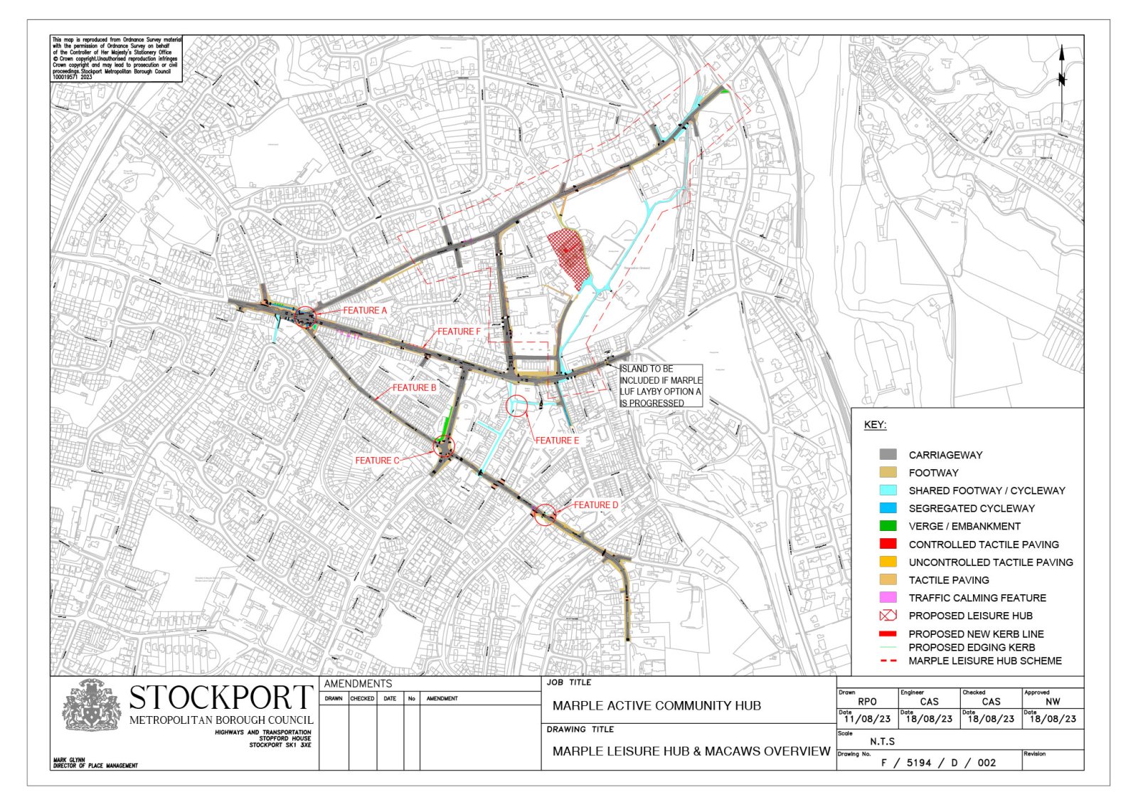
The plans come in two parts, with the first a set of basic improvements and road crossings around the new “active community hub” (library, pool and health centre) to replace the existing library in Memorial Park. These are already funded and would happen within the next year or so.
Slightly more aspirational, but still pretty bare-minimum, are the ideas in the ‘Marple Area Cycling and Walking Strategy’ (MACAWS); a rather grand title for a plan which again largely consists of cycling and walking crossings over the town’s busy roads, with no real wider strategy nor links to anywhere outside the apparent island nation of Marple. It’s also unfunded, so potentially years away given current timescales, but the benefit there could be more time to fine-tune what’s needed.
More than anything, it seems the council is oddly keen for Marple’s ever-present motor traffic to continue dominating its centre, rather than it be humanised into more of a place for people to exist and enjoy. There’s no apparent aspiration to actually reduce current, strangling traffic levels. Rejecting this on an ideological basis would come at the strong risk of the entire plan being dumped, though, so maybe we should be glad that some decades-old frustrations could finally be fixed.
Here’s a rattle through what’s proposed. Please complete your feedback by this Monday 9th October!
Active Community Hub Connections
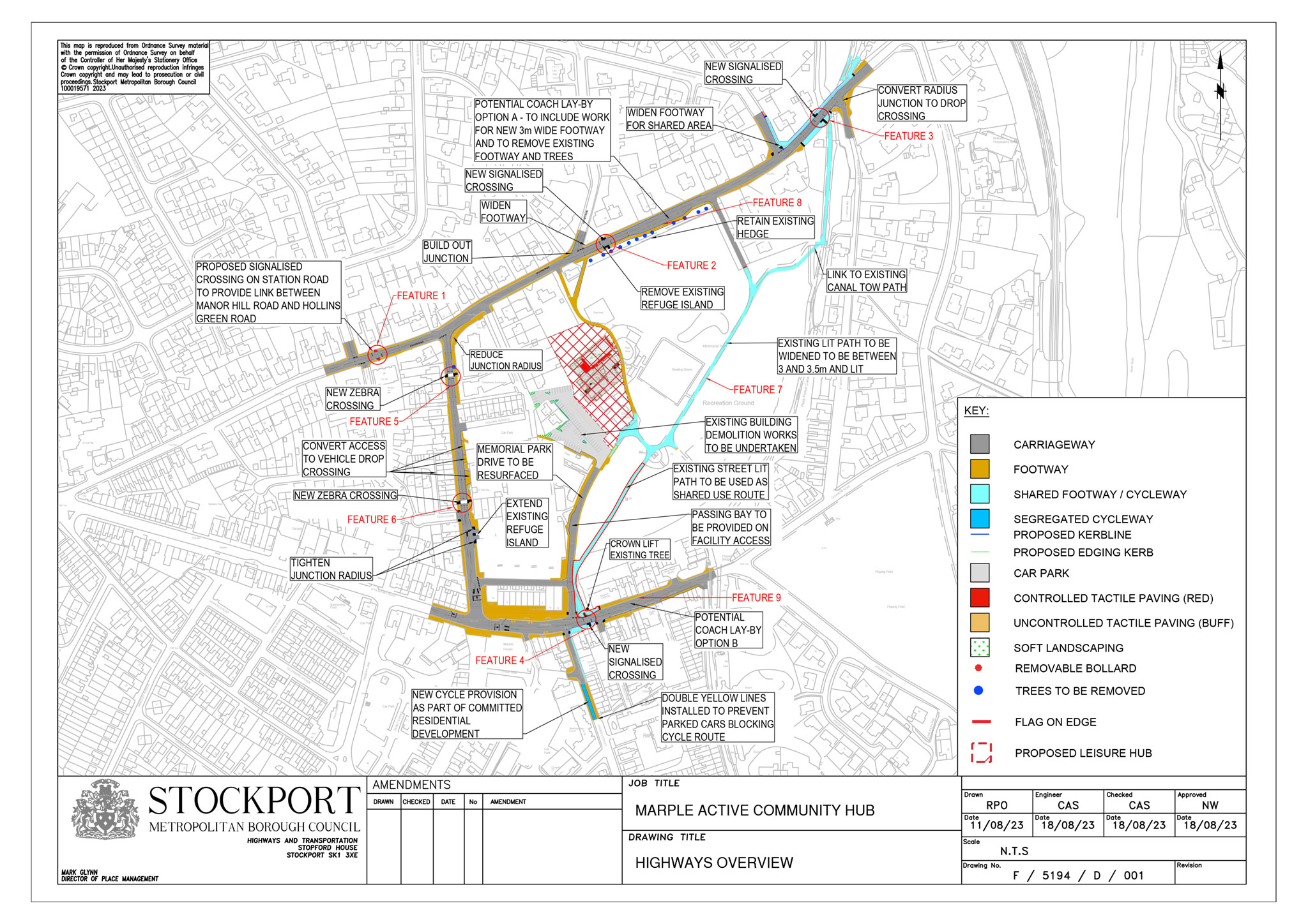
Finally, a desperately needed toucan crossing on Brabyns Brow beside Marple canal locks. Will the pavement on the north side actually be widened for shared use? Not clear. And why no link down to Marple railway station? Much of that pavement is already wide enough.
Two zebra crossings on Hollins Lane, I’m not sure in entirely the right places (would be better south of Fern Close, on the desire line from Asda). Funny story — I once suggested a zebra crossing here on the Walk Ride Marple Facebook group only to get shouted back that it’d be unnecessary and can’t people walk down to the traffic lights. Oh well here we are.
A toucan beside the cinema and park entrance, offering an easier link over from the filtered Church Street, a route I seem to use constantly, is a welcome idea but poorly executed for cycling (really no space for a sparrow with separate lanes?) and may prove frustrating if linked to the lengthy timings of the main traffic light junction, where pedestrians frequently choose to just run across.
Widening the main path through the park might seem an easy win, but it’s a busy and frustrating place to cycle already. Even at 3 metres wide, it’ll be a constant conflict of users, not really acceptable as a key cycle route and feeling very isolated at night. Why not a new cycle path on the space alongside Station Road instead, linking from the new hub to the Brabyns crossing?
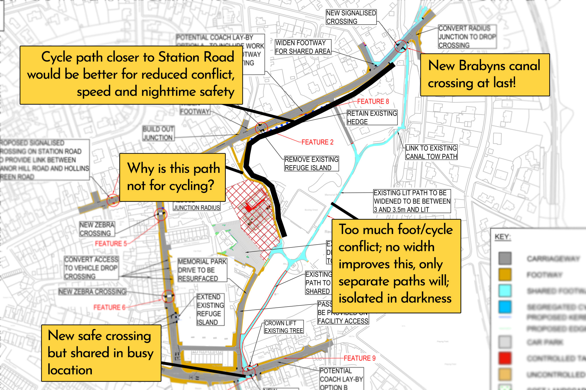
But then why is the path heading north, past the new pool to Station Road, not marked as shared for cycling? Many people cycle the existing path here, will this become ‘disallowed’? And why is the new Station Road crossing beside Ley Hey Road not a toucan or sparrow, connecting into the neighbourhood to the north? A very odd decision. In fact, you could do something bold here and close the junction of Ley Hey Road to traffic, with a shared “sparrow” crossing leading directly across to it from the park, on the actual desire line.
Finally, it’s a surprise to see the aged and poorly designed filter on Church Street is already earmarked for upgrade with funds from the nearby canal wharf development.
A few years ago I managed to get a “cycle lane” marking applied to stop it being blocked by cars, this should go much further. It’s a great quiet route into the town from the canals and All Saints area.
Marple Area Cycling and Walking Strategy (MACAWS)
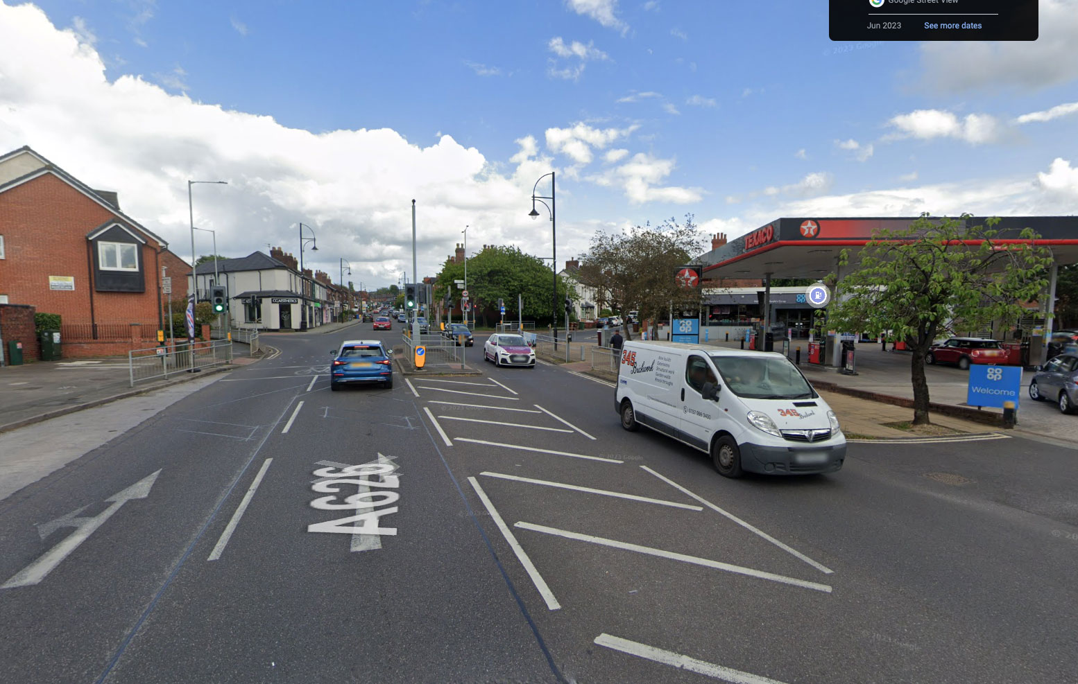
Everything here really hinges on blocking through traffic from the bottom of Church Lane, another basic, long-needed intervention but still a reasonably bold aspiration, at a time when any minor curtailing of driving risks overblown uproar. Currently it’s one-way and supposedly a 20 zone but treated by many impatient drivers as a rocket-launch up to the equally awful roundabout with Hibbert Lane, which they shoot over barely looking.
I do worry the narrow width and parked cars might still make it a less-than-ideal quiet street for cycling, but honestly feel this proposal would solve so much for cycling east-west across and into Marple. Key to this would be the complete redesign of the three-way “Jolly Sailor” junction with a new CYCLOPS: a junction pioneered in Manchester where cycling and walking are kept separate.
This nifty CYCLOPS would allow easy cycling diagonally NW/SE across the A626 to link into Bowden Lane and onwards to the town’s largest schools, Rose Hill, Marple Hall and the Alan Newton Way. Stockport Road would have a single stage crossing for pedestrians, replacing the current cattle fence ugliness, and the humongous junction mouth of Bowden Lane would be shrunk, making walking much easier and more pleasant.
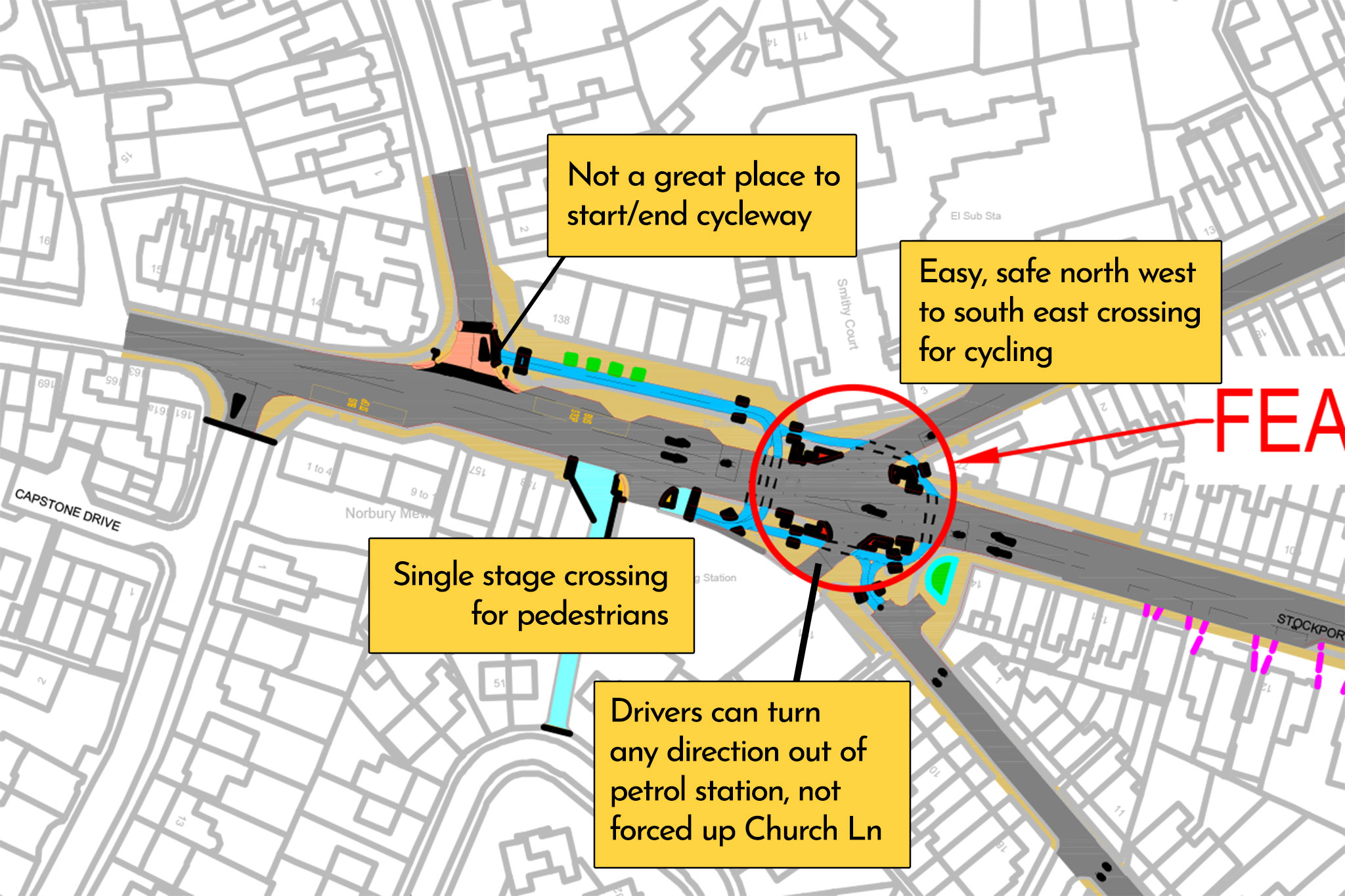
One thing I sadly don’t like is the way the cycle lane from the CYCLOPS joins Bowden Lane, right at the junction. Likely there’ll be a car waiting there, blocking the access or restricting view. Could the lane not be extended a little further in? Getting this wrong risks undermining the whole (very expensive) junction. As for Bowden Lane itself, how about restricting traffic over the railway bridge completely, or just at peak times, if this is really to be a safe cycle route for school kids?
Changing the Hibbert Lane roundabout to a traffic-light controlled junction should hopefully give an easier cycle over to the rest of Church Lane, up to the town centre shops, housing and canal. It’s proposed to extend the town centre 20 zone, but only half way up the steep hill to All Saints Church. Why stop there? This sensible limit should continue all the way to where it becomes Ridge Road, if not onto The Ridge itself. Which leads on to…
What’s missing?
A 20 mph limit for all residential streets, surely? Marple is sorely lacking sensible speed limits compared to many other areas of Stockport. Currently the busy, traffic-dominated centre of the town is a 20 mph zone introduced at the start of the pandemic (albeit largely invisible and ignored due to poor signage and placemaking), yet almost all surrounding minor residential roads remain the standard 30.
If the council is serious about people shifting to walking and cycling, and given their proposals continue to push cycling onto these “quiet streets” rather than build actual cycle lanes, then a switch to 20 mph for pretty much the whole of urban Marple is absolutely vital. I simply cannot understand why this wouldn’t be part of such a “strategy”, given the huge evidence in its favour, and it is essential we push it as strongly as possible.
Another odd omission is cycle parking. Unless we’re to assume this’ll magically appear from other cash pots, there’s no proposal to significantly increase the number of Sheffield stands within the town, which are already well-used and lacking in number. Sometimes highways planners seem to forget people cycling have destinations too, we don’t (just!) ride round in circles.
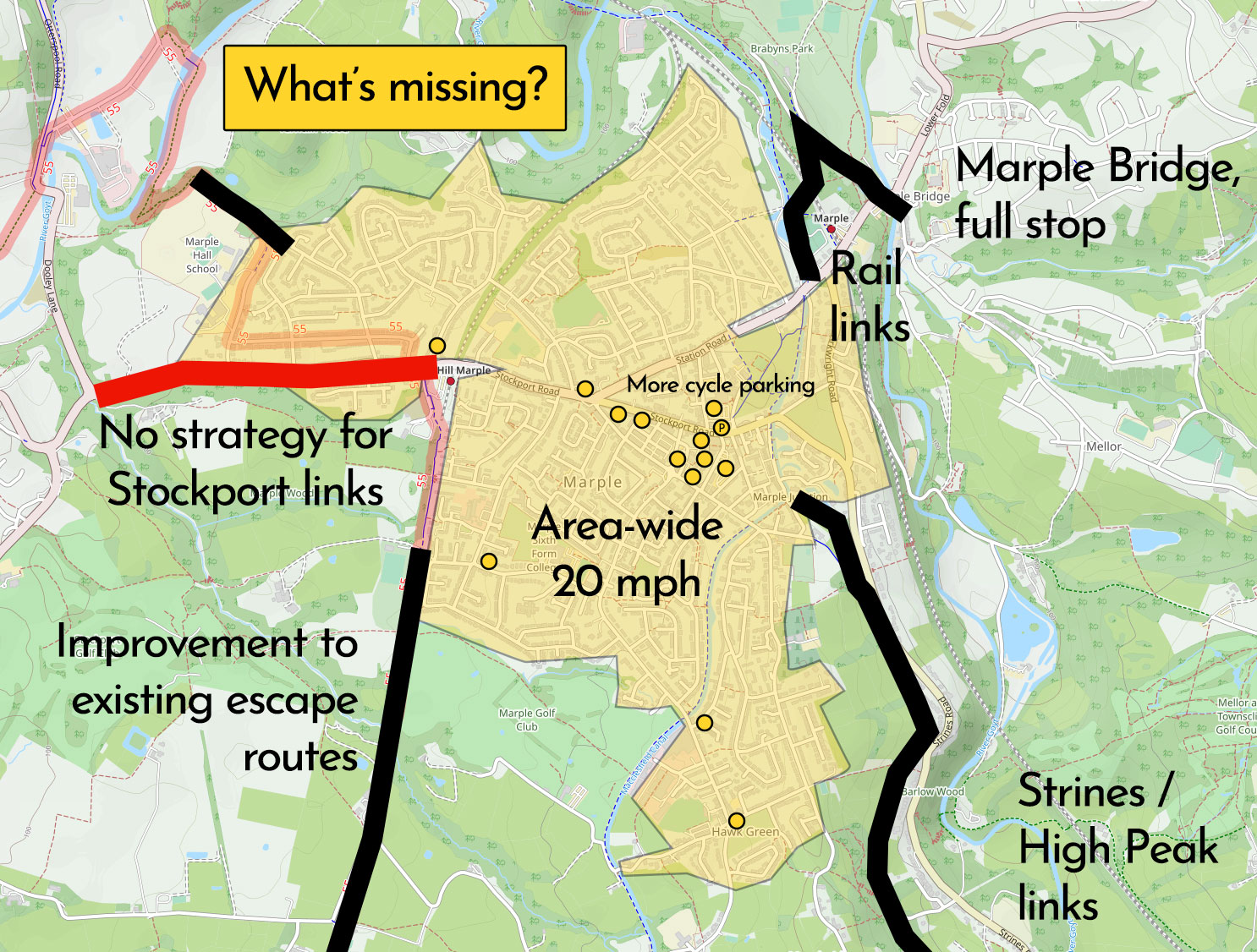
Is ‘MACAWS’ meant to focus purely on movements around and within Marple? I’m not sure, but completely ignoring the awful daily traffic queues leaving the town misses a key issue. Most of Marple’s traffic problems are caused by a lack of good peak time travel options into Stockport and neighbouring areas.
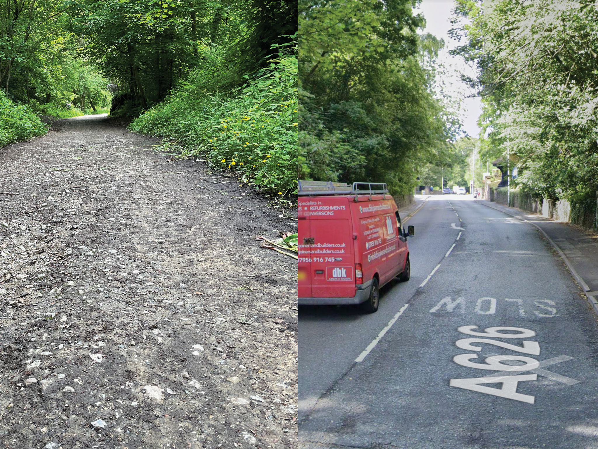
Failing a complete rebuild of the A626, would it be so much to ask for some basic improvements to the existing Middlewood Way (linking to Hazel Grove, High Lane, etc) and Alan Newton Way; resurfacing them at the very least with a better year-round surface? People desperately need viable, appealing alternatives to sitting in that queue.
Then there’s Marple Bridge, entirely forgotten. It’s possible to avoid the hellish climb of Brabyns Brow with a practically hidden path through Brabyns Park, but it’s bumpy and unlit. Shouldn’t a good, safe and signposted link between Marple and Marple Bridge be an absolute priority? As should a cycle link to the main railway station, completely ignored here. Ultimately ‘MACAWS’ is just a single highways project, not a real “strategy” in any sense.
Well, oops, that was meant to be a few words. A couple of quick thoughts to push you to respond to the consultation before Monday, but alas my 30+ year lifetime of living and cycling around this corner of GM got the better of me.
While it may just highlight past failure, even these pretty basic proposals would be the biggest thing to happen for cycling and walking across Marple in over three decades.
Make sure you have your say now: absolutely question, suggest, request; but above all support the cause, so we’re not waiting another lifetime for these urgent basic fixes.
Found this useful? Want to support my work on Peaks & Puddles? Buy me a coffee or get exclusive extra routes and downloads with Peaks & Puddles + for a one-off contribution: it all helps to support writing and sharing posts like this campaigning for better local facilities.