Mills and Brows

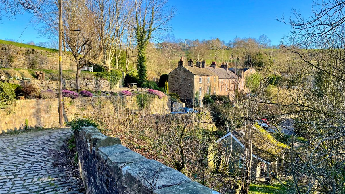
Traversing the hills around Marple and New Mills, trace industries past and present up the steep, green valley sides to the quiet lanes of Mellor and the (almost) never-ending descent through the hidden hamlet of Mill Brow.

Route details

  • Distance 14.3 miles / 23 km
  • Elevation Gain 371 m / 1218 ft
  • Time allow 2 hours
  • Difficulty Moderate
  • Suited to Gravel Bike Hybrid Bike Mountain Bike Road Bike
  • Notes Mostly moderate with one very sharp climb. One slightly bumpy short gravel track. Reasonably good canal towpath. A few narrow bridges and trail gates.

Water has meandered down the lush valleys of the rivers Goyt and Sett, towards what is now the conurbation of Greater Manchester, for millennia. But in the 18th Century, a wave of industry flowed out the other way, transforming this hilly landscape into a powerhouse of production.

“Modern” large-scale mills sprang up all around Marple, New Mills and Hayfield from the late 1700s through to the early 1900s. The damp, deep valleys made the area ideal for cotton production, an offshoot of Manchester’s “cottonopolis”, with both power and water provided by the fast-flowing rivers.

While textile production provided the bulk of the work, leading to huge increases in the population of local villages and hamlets, the mills also included bleach works, paper, candlewicks and in particular the dying or printing of cloth.

These “Calico” printworks became perhaps the most prominent local industry, with the Strines Printworks and its chimney remaining right up until 2007.

Starting from the centre of Marple, right beside where the Hollins Mill once dominated the town centre, this route weaves a picturesque, moderately challenging route out into the valleys using parts of the Peak Forest Canal and Sett Valley Trail, the former railway branch to Hayfield.

On the return, the strenuous climb to the top of Mellor pays off with a wondrously long, little-known cycling descent as you turn off Shiloh Road to Chatterton Lane. A highlight of the entire spin, it threads joyously down through the hamlets of Hollywood End, Holly Vale and appropriately enough, Mill Brow.

Route map

The route stats featured here are automatically generated by Komoot. For the most accurate guide, please refer to the route details above, based on actual rides recorded by Strava.

Where to start

Marple town centre is a good place to start this loop, with several other linking routes and only a modest initial climb before long sections of gentle off-road trails. Starting and finishing at Memorial Park Drive, at the entrance to the town’s main park, there are plenty of shops and cafés nearby too.

The Lower Peak Forest Canal links in from RomileyWoodleyHydeDukinfield and Ashton-under-Lyne, while the Upper Peak Forest Canal makes an easy route from Whaley Bridge and the bumpier Macclesfield Canal links from High Lane.

From the Middlewood Way, see the quiet road route using Mount Drive and Woodville Drive mapped (in reverse) in the Lyme Loop cycle route guide. From the Alan Newton Way and central Stockport, stick to the north side of Marple, using Bowden Lane and Norbury Drive to join the route at Lock 7 off Grosvenor Road.

Alternatively, from the centre of New Mills, follow High Street downhill to link into the route at St George’s Road.

By train: Marple railway station on the Manchester to Sheffield line is just a short distance down Brabyns Brow from the end of the route (you might want to walk it, it’s not a particularly pleasant road to cycle). Otherwise, New Mills Newtown railway station on the Buxton line is convenient to join near where the route leaves the canal and heads down Albion Road.

By car: Memorial Park pay car park in Marple is perfect for the start of the route. Alternatively, Brabyns Park has a free car park right beside the end of the route, though a loop from here will start with a longer initial climb.

Things to note

  • The Peak Forest Canal towpath here is slightly bumpy in places and can be puddled after wet weather, so wider tyres — and mudguards in winter — are advised. It’s still far more pleasant than nearby roads like the B6101. Similarly, Rollins Lane in Compstall near the end of the route is rather bumpy, and the track up from Brabyns Park isn’t as good as it should be.
  • Quiet lanes and off-road trails make up almost this entire route. Two busier roads are only used very briefly, to link things together: Albion Road at New Mills and Compstall Road. Both are downhill, with easy left turns off them.
  • Although just about within the ‘Moderate’ difficulty category, with most of the route either flat or downhill, when the climbs come here they are quite challenging on their own, so be prepared! Briargrove Road up to Moorend (Mellor) is by far the fiercest, not too long but certainly steep. Thankfully it’s very quiet, so no problem if you need to catch your breath or even walk it.
  • Chatterton Lane (which becomes Hollywood Road and then Mill Brow) is a brilliant descent, but very narrow and twisty. It’s particularly hard to see around the bends in summer, so best to err on the cautious side.
  • See the Upper Peak Forest Canal cycle route guide and Sett Valley Trail cycle route guide for more things to note about these specific sections. Remember to take it easy on the canal towpath in particular and slow right down when passing others. From behind, ask to pass well in advance by bell or a friendly voice, then wait until a signal that you’re welcome to pass.
  • Barriers: Three narrow canal bridges with cobbles and other narrow sections of path. Four standard (excessive) gates on Sett Valley Trail. Rather tight chicane at Brabyns iron bridge.

Route stage-by-stage

  1. From Memorial Park Drive in Marple, turn right onto Stockport Road then immediately left, into Church Street. Continue uphill, using the dropped kerb and cycle markings to pass through the bollards on this quiet backstreet which takes you all the way up to Marple’s main canal wharf. At the top, continue right and approach the t-junction.
  1. Turn left onto Church Lane and begin the climb up to “the ridge”, passing immediately over the Macclesfield Canal. Near the top, notice the unusual freestanding bell-tower of All Saints Church, retained when a new church was built in 1880 to house the growing local population. As you crest the brow of the hill onto Ridge Road, look right for glimpses of Goyt Mill, the last cotton mill to be built in the area. Construction of its imposing terracotta and buff brick hulk began in 1905.
  1. Suddenly the suburban houses end and, becoming simply The Ridge, the road delivers a stunning view over the valley. Cobden Edge rises on the opposite side of the River Goyt while in the distance, below the hills of the High Peak, is New Mills and the prominent chimney of a mill to be encountered later. Continue climbing around an s-bend and between houses to reach Ridge End, where a straight, flat summit gives glorious views over Derbyshire to the left and the Cheshire plain to the right. Drop down past Ridge Quarry then turn left at the sharp blind bend into Hollinwood Road. Unthinkably once a through road, today this narrow filtered lane leads thrillingly down the hillside only for unmotorised traffic, with a splendid view of the canal ahead.
  1. Cross the Peak Forest Canal and loop around to the left to join the towpath, turning left. Follow this beautiful and fairly quiet waterway for 4.6 km (2.9 miles), first passing Strines where the large printworks once stood in the valley below, utilising small wharfs for coal and goods either side of Strines Aqueduct. Further along, the drone of Waterside Mill can be heard as the canal bends towards Disley in Cheshire. Built for cotton finishing by Samuel Oldknow, mastermind of much local industry and the waterway itself, it now produces tissue. Houses have now replaced another large mill, beyond Bridge 26. Through dense woodland the towpath enters Derbyshire only to emerge noisily alongside what was Brunswick Mill, producing candlewicks, later turned to sweet production by Swizzels Matlow. The confectioner relocated from London during the Second World War and now fills this area of New Mills with the permanent scent of sugary childhood memories.
  1. Soon after passing under Bridge 28, taking care on the uneven cobbles, turn left and leave the towpath onto Victoria Street. Where it meets Albion Road, turn right and head downhill to the traffic lights on this busier road. Continue straight ahead, crossing the River Goyt on Queens Bridge, the first high level bridge across the town’s dramatic Torrs gorge, built in 1835. Turn left into Hyde Bank Road, which follows above the River Sett first alongside terraced stone cottages then dropping to an industrial waterside area including a converted wool mill. Where the road approaches a bridge over the river, Salem Mill once sat straight ahead, beginning life in 1390 as a corn mill named New Mylne, eventually giving the town its name. Don’t cross the bridge but instead take the tight right turn just before into St George’s Road, doubling back sharply up a whimsically narrow curve.
  1. Take care around the blind bend and continue briefly uphill past a cemetery. Here, through a gate on the left, join the Sett Valley Trail with a short slope and follow the former New Mills to Hayfield branch line railway for the next 2.3 km (1.4 miles). The sides of the disused trackbed are now thick with vegetation and woodland but it’s still possible to see glimpses of the hills closing in and continued industry in the valley below, where Watford Bridge Printworks once stood. The trail crosses High Hill Road with gates either side, then continues slightly uphill above the site of Garrison Works, built for Calico printing in 1800 and later a bleachworks. Where the trail appears to fork, stay left and it drops slightly to meet Station Road at Birch Vale.
  1. Leave the trail and turn left, passing the charming Sett Valley Café, an ideal refreshment spot. The road becomes Spinnerbottom as it crosses the river, where to the right Birch Vale Printworks once stood. While the Calico mill is gone, the large millpond remains as a reservoir beyond and the beautiful, unusual curved terrace of workers cottages is worth admiring. A short climb past an old Post Office, a telephone box and a pub completes the very northern English scene, leading to the wooded Sycamore Road and the hamlet of Thornsett. Below an old school house, turn right onto Aspenshaw Road, curving gently uphill around the side of Thornsett Brows and the quaint, current primary school.
  1. At a small triangular junction, turn left onto Briargrove Road. Though by far the most challenging uphill section of the route, it starts with a swift descent to the brook which flows down from Rowarth. It can feel a good idea to hold onto that momentum, then, even if the stiff climb which follows sucks it up immediately. While the average grade is about 10% over the 1 km (0.6 mile) struggle, a dramatically steeper section comes as the lane twists in an s-bend beside large farmhouses. Eventually it emerges onto the open side of Mellor Moor; reaching the top, be sure to take in the stunning view to Kinder Scout behind.
  1. Turn right onto Mellor Road then immediately right again onto Shiloh Road, signposted for Rowarth. A wide vista opens out across the fields towards Cown Edge, Matley Moor and Chunal Moor. After the road narrows and descends between trees, turn left immediately after the stone building which was previously the Moorfield Arms pub.
  1. The route now descends almost continuously for over 5 km (3 miles), starting here on Chatterton Lane with views of Stockport and Manchester in the distance. After 1.2 km (0.75 miles) it bends right sharply onto Hollywood Road, descending further with several tight, blind bends. Numerous small mills and mill ponds were nestled just in this tight brook, including Hollyhead Bleach Works, Hollyvale Mill for candlewick spinning and Primrose Mill for cotton. Crossing the brook, the lane enters Mill Brow itself, a conservation area with a popular pub. Continuing around the hillside, bear right onto Ley Lane.
  1. At the junction with the busy A626 Glossop Road, turn right (take care, poor visibility) then immediately left onto Cote Green Road. This continues the descent ever further, dropping from Lane Ends through Cote Green into the village of Compstall. At a t-junction, turn right onto Cote Green Lane, following it around over speed bumps, then take the second right just before a large Methodist chapel onto Belmont Drive. Turn left onto Ernocroft Road and the busy B6104 Compstall Road is now ahead — luckily, most of it has just been avoided.
  1. Turn right onto Compstall Road, then drop downhill for just 0.25 km (0.15 miles) and turn sharply left into Rollins Lane. This is signposted for Brabyns Park but it can still be tricky to spot at speed. A narrow bridleway and private road, the surface is bumpy in places as it descends further into the valley and you’ll hope not to encounter any cars when the verges are in full growth. Soon the lane approaches the magnificent Iron Bridge, built in 1813 by Salford Iron Works. Entering Brabyns Park, continue straight ahead on the gravelly path which takes you over the playing fields, between a group of trees and towards the looming bank of the valley-side which holds Marple above.
  1. Join the tarmac lane along the side of the woodland and follow it until just before the main car park. Here, double back sharply to the right on an inclined gravel track which snakes up the hillside. Bear left and continue climbing, soon crossing the railway line on an old stone bridge near Marple station. A large stone retaining wall then appears ahead, supporting the Peak Forest Canal. After the track veers left, the best route is through the narrow stone bollards on the right, to join the canal towpath, since the path ahead can be muddy. Turn left on the towpath, climbing past Lock 8 of the Marple Lock Flight.
  1. Approaching Brabyns Brow, which we’ve just thankfully avoided entirely, cross straight over (which can take some patience) and veer right to continue beside the canal. Pass Lock 9 and Oldknow’s Warehouse, built in 1801 to tranship goods from boats undercover. Just as the path climbs again for Lock 10, turn right into Marple’s Memorial Park using the sharp, snaking tarmac path. The park was opened in 1922 to commemorate those lost in the First World War, with land donated by local families. Turn left to follow the main avenue through the park, past the War Memorial with its views of the hills just conquered, and complete the loop.

Other route options

  • Missing Marple Ridge
    13.9 miles (22.4 km), 1075 ft (328 m), Moderate
    The initial climb of this route goes up to Ridge End only to drop swiftly right back down to join the canal. It is absolutely worth it for the stunning views, giving a complete overview of the landscape ahead (and to skip a few bumps and puddles on the towpath) but, for a gentler start, turn left after the canal bridge on Church Lane and follow Brickbridge Road (beside a primary school and through the bollards at the end) to join the Upper Peak Forest Canal there and then.
  • Branch to Hayfield
    16.6 miles (26.7 km), 1542 ft (470 m), Challenging
    From Station Road at Birch Vale, it’s only another 1.5 km (0.9 miles) into Hayfield, making it an easy diversion. For a more challenging return to the loop, you could then try the strenuous climb up Swallow House Lane, a quiet back road strung halfway up Lantern Pike with fabulous views over the valley. This adds about 100 metres (350 ft) of steep climbing and deposits you neatly back for the right turn into Aspenshaw Road, upping the route to ‘Challenging’ territory.

These options are included as separate GPX files and mapped out with full directions in the Mills and Brows Pocket Guide & GPX download. Also available as part of the Cycle Routes Pocket Guide Collection and Cycle Routes GPX Collection.

Original photography, words and design by Anthony Sheridan unless indicated otherwise. Found this guide helpful? Buy me a coffee to help keep the wheels turning!

The all-important disclaimer: While great care and attention has been put into gathering these routes, ensuring details are accurate and determining their suitability, all information should be used as a guide only and is not a replacement for using your own judgement or research when setting out on new adventures. Peaks & Puddles/the author cannot be held responsible for any issues that may arise from the riders own decision to ride a section of indicated route.

Always ensure your equipment is safe and legal for use and that you are well prepared, carrying everything necessary including access to a good map. Follow the Highway Code and the Countryside Code at all times. Respect the landscape, the wildlife and the people you encounter. And after all that, have fun!